IMAGES TAKEN NEAR TO
Tumbling Bay Weir, Star Street, WARE, SG12 7AW
Introduction
This page details the photographs taken nearby to Tumbling Bay Weir, Star Street, SG12 7AW by members of the Geograph project.
The Geograph project started in 2005 with the aim of publishing, organising and preserving representative images for every square kilometre of Great Britain, Ireland and the Isle of Man.

There are currently over 7.5m images from over14,400 individuals and you can help contribute to the project by visiting https://www.geograph.org.uk
Image Map (Loading...)


Getting Data...Please wait
Leaflet Map data © OpenStreetMap
Images are licensed for reuse under creativecommons.org/licenses/by-sa/2.0
Notes
- Clicking on the map will re-center to the selected point.
- The higher the marker number, the further away the image location is from the centre of the postcode.
Image Listing (88 Images Found)
Images are licensed for reuse under creativecommons.org/licenses/by-sa/2.0
Image
Details
Distance
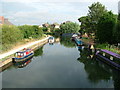
1
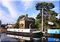
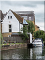
By Tumbling Bay Weir
The weir is below the walkway on the left. The house is boarded up, which seems a shame, but the garden is enjoyed by moored up boaters.
Image: © Des Blenkinsopp
Taken: 13 Sep 2012
0.01 miles
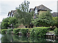
3
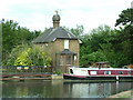
Tumbling Bay Weir on the Lea Navigation
The derelict keeper's cottage beside Tumbling Bay Weir on the River Lea Navigation in Ware.
Image: © Rob Candlish
Taken: 24 Jun 2010
0.02 miles
4
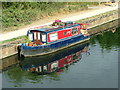
"Pug"
"Pug", a miniature narrow boat moored between Tumbling Bay Bridge and Tumbling Bay Weir on the River Lea Navigation in Ware. Normally narrow boats are at least twice as long as this one, if not more.
Image: © Rob Candlish
Taken: 27 Jul 2010
0.04 miles
5
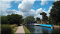
River Lea near Ware, Hertfordshire
Image: © Christine Matthews
Taken: 19 Jun 2016
0.05 miles
6
River Lea near Ware, Hertfordshire
Image: © Christine Matthews
Taken: 19 Jun 2016
0.05 miles
7
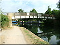
Tumbling Bay Bridge, River Lea Navigation
A footbridge just south of Tumbling Bay Weir on the River Lea Navigation.
Image: © Rob Candlish
Taken: 27 Jul 2010
0.05 miles
8
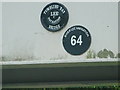
BWB plaques
British Waterways Board plaques on Tumbling Bay Bridge giving its name and bridge number. BWB always refers to this waterway as the River Lee Navigation, whereas locals always spell it Lea.
Image: © Rob Candlish
Taken: 27 Jul 2010
0.05 miles
9
View from Tumbling Bay Bridge, River Lea Navigation
Looking towards Ware town centre from Tumbling Bay Bridge. Notice the miniature narrow boat moored to the left.
Image: © Rob Candlish
Taken: 27 Jul 2010
0.05 miles
10

Fire in the sky
An impressive sunrise over the River Lea Navigation in Ware seen from the balcony of a riverside apartment.
Image: © Rob Candlish
Taken: 18 Jul 2010
0.06 miles