IMAGES TAKEN NEAR TO
Ermine Street, WARE, SG12 0SY
Introduction
This page details the photographs taken nearby to Ermine Street, SG12 0SY by members of the Geograph project.
The Geograph project started in 2005 with the aim of publishing, organising and preserving representative images for every square kilometre of Great Britain, Ireland and the Isle of Man.

There are currently over 7.5m images from over14,400 individuals and you can help contribute to the project by visiting https://www.geograph.org.uk
Image Map (Loading...)


Getting Data...Please wait
Leaflet Map data © OpenStreetMap
Images are licensed for reuse under creativecommons.org/licenses/by-sa/2.0
Notes
- Clicking on the map will re-center to the selected point.
- The higher the marker number, the further away the image location is from the centre of the postcode.
Image Listing (34 Images Found)
Images are licensed for reuse under creativecommons.org/licenses/by-sa/2.0
Image
Details
Distance
2
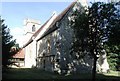
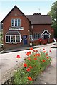
Wadesmill: Ermine Street
Ermine Street is an old Roman road. Normally these are very straight but occasionally, as here, the straightness principle was abandoned in order to overcome some particular geographical obstacle, probably in this case the crossing of the River Rib.
There is an interesting historical name change going on in this village too. If you look at old Ordnance Survey 6" to the mile maps the whole settlement along Ermine Street on either side of the River Rib was shown as Wadesmill, while Thundridge was the name of the much larger parish centred on the church Image at the top of the hill at the southern end of the village. Certainly this naming arrangement was recorded as recently as the map edition of 1950, where the word Thundridge can only be found by zooming out of the mapping to show the whole parish. However all the current editions of the OS mapping now refer to Thundridge as the settlement on the south side of the river while Wadesmill has migrated so that it now only covers the village on the north side. There is too a howler in the current OS 1:25,000 scale mapping which refers to Thundridge as Thunderidge.
Image: © Nigel Cox
Taken: 25 Nov 2007
0.01 miles
3
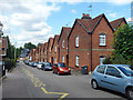
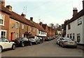
Terrace on Ermine Street, Thundridge
There is a stone set into the frontage some way down telling us that the cottages were erected in 1864 in memory of Caroline Hanbury. Additions to the row are dated 1888 and 1901. A grade II listed building.
Image: © Robin Webster
Taken: 21 Aug 2015
0.02 miles
5
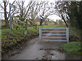
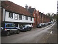
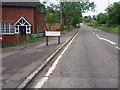
Thundridge: Old Church Lane
Old Church Lane leads, unsurprisingly, to the ruined old Church of St Mary and All Saints. However since the construction of the A10 Wadesmill Bypass it has been truncated for public vehicle use, and the national speed limit signs beyond the gate are now somewhat redundant. Beyond the embankment to the left is the River Rib.
Image: © Nigel Cox
Taken: 25 Nov 2007
0.06 miles

8
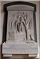
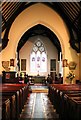
St Mary, Thundridge, Herts - Wall monument
Image: © John Salmon
Taken: 13 Sep 2003
0.07 miles