IMAGES TAKEN NEAR TO
Sacombe Green, WARE, SG12 0JH
Introduction
This page details the photographs taken nearby to Sacombe Green, SG12 0JH by members of the Geograph project.
The Geograph project started in 2005 with the aim of publishing, organising and preserving representative images for every square kilometre of Great Britain, Ireland and the Isle of Man.

There are currently over 7.5m images from over14,400 individuals and you can help contribute to the project by visiting https://www.geograph.org.uk
Image Map (Loading...)


Getting Data...Please wait
Leaflet Map data © OpenStreetMap
Images are licensed for reuse under creativecommons.org/licenses/by-sa/2.0
Notes
- Clicking on the map will re-center to the selected point.
- The higher the marker number, the further away the image location is from the centre of the postcode.
Image Listing (7 Images Found)
Images are licensed for reuse under creativecommons.org/licenses/by-sa/2.0
Image
Details
Distance
1
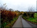
Autumn colours in hedgerow, Rowney Lane, Sacombe Green
Image: © Bikeboy
Taken: 2 Dec 2013
0.07 miles
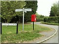
5
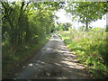
Sacombe: Rowney Lane
Rowney leads from Sacombe Green to Rowney Priory. The OS show a height of 116 metres above sea level along the lane in this vicinity.
Image: © Nigel Cox
Taken: 21 Sep 2014
0.20 miles
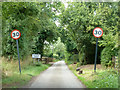
6
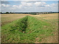
Sacombe: Watershed drainage ditch near Rowney Priory
This is the start of a drain that flows westwards into Dane End Tributary and thence via the River Beane into the River Lee. Behind the photographer the drainage is to the east and via the River Rib into the Lee. Rowney Lane passes along the watershed and the OS show a height of 116 metres above sea level on the road.
Image: © Nigel Cox
Taken: 21 Sep 2014
0.21 miles
7
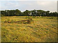
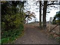
Sacombe Green
An ancient cart is ignored by the cows in this field.
Image: © Nigel Cox
Taken: 30 Jun 2006
0.22 miles