IMAGES TAKEN NEAR TO
Wellpond Green, WARE, SG11 1NR
Introduction
This page details the photographs taken nearby to Wellpond Green, SG11 1NR by members of the Geograph project.
The Geograph project started in 2005 with the aim of publishing, organising and preserving representative images for every square kilometre of Great Britain, Ireland and the Isle of Man.

There are currently over 7.5m images from over14,400 individuals and you can help contribute to the project by visiting https://www.geograph.org.uk
Image Map
Images are licensed for reuse under creativecommons.org/licenses/by-sa/2.0
Notes
- Clicking on the map will re-center to the selected point.
- The higher the marker number, the further away the image location is from the centre of the postcode.
Image Listing (9 Images Found)
Images are licensed for reuse under creativecommons.org/licenses/by-sa/2.0
Image
Details
Distance
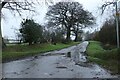
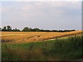
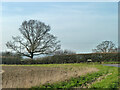
2
Trees by Church Lane
Church Lane runs along this side of the hedge. Trees on the right stand each side of the entrance to a drive to a farm called Standon Friars. The foreground crop looks like oil seed rape.
Image: © Robin Webster
Taken: 13 Mar 2014
0.15 miles
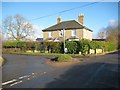
4
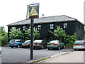
The Kick & Dicky Pub
An unusual name for this pub in Wellpond Green. It used to be known as The Nags Head.
Image: © Melvyn Cousins
Taken: 30 May 2006
0.20 miles
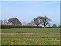
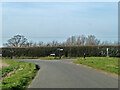
6
Standon: Wellpond Green road junction
The photographer sincerely trusts that the desultory small but high grassy mound at the road junction is not the eponymous green.
Image: © Nigel Cox
Taken: 19 Jan 2014
0.22 miles
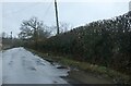
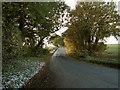
7
Rural road junction
Bromley Lane meets Hadham Road, left, and Chapel Lane, right.
Image: © Robin Webster
Taken: 13 Mar 2014
0.22 miles
9
Tree by Hadham Road
Looking from Bromley Lane.
Image: © Robin Webster
Taken: 13 Mar 2014
0.24 miles