IMAGES TAKEN NEAR TO
MUCH HADHAM, SG10 6JG
Introduction
This page details the photographs taken nearby to SG10 6JG by members of the Geograph project.
The Geograph project started in 2005 with the aim of publishing, organising and preserving representative images for every square kilometre of Great Britain, Ireland and the Isle of Man.

There are currently over 7.5m images from over14,400 individuals and you can help contribute to the project by visiting https://www.geograph.org.uk
Image Map
Images are licensed for reuse under creativecommons.org/licenses/by-sa/2.0
Notes
- Clicking on the map will re-center to the selected point.
- The higher the marker number, the further away the image location is from the centre of the postcode.
Image Listing (9 Images Found)
Images are licensed for reuse under creativecommons.org/licenses/by-sa/2.0
Image
Details
Distance
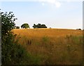
3
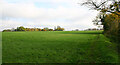
Grassy plateau north-west of Green Tye
The countryside hereabouts is characterised by flat terrains incised by streams which have created wooded mini-valleys.
Image: © David Kemp
Taken: 12 Nov 2022
0.14 miles
5
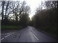
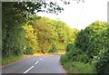
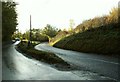
The B1004 at the junction of Parsonage Lane
Image: © David Howard
Taken: 25 Apr 2012
0.16 miles
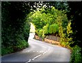
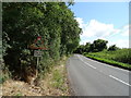
8
Parsonage Lane joins the B1004
There is a grass triangle at the junction, but it has an extremely acute angle towards Bishop's Stortford, the roads running in parallel but at different levels.
Image: © Robin Webster
Taken: 16 Mar 2014
0.21 miles
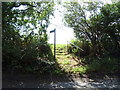
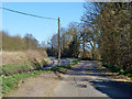
9
Road junction on the B1004
The road off to the left leads to Green Tye.
Image: © Robert Edwards
Taken: 29 Oct 2008
0.21 miles