IMAGES TAKEN NEAR TO
Malting Lane, MUCH HADHAM, SG10 6AW
Introduction
This page details the photographs taken nearby to Malting Lane, SG10 6AW by members of the Geograph project.
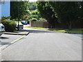
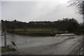
The Geograph project started in 2005 with the aim of publishing, organising and preserving representative images for every square kilometre of Great Britain, Ireland and the Isle of Man.

There are currently over 7.5m images from over14,400 individuals and you can help contribute to the project by visiting https://www.geograph.org.uk
Image Map
Images are licensed for reuse under creativecommons.org/licenses/by-sa/2.0
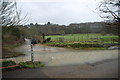
Notes
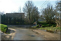
- Clicking on the map will re-center to the selected point.
- The higher the marker number, the further away the image location is from the centre of the postcode.
Image Listing (42 Images Found)
Images are licensed for reuse under creativecommons.org/licenses/by-sa/2.0
Image
Details
Distance
1
Much Hadham
Ash Meadow looking from the High street
Image: © Raymond Cubberley
Taken: 19 Jul 2011
0.05 miles
2
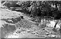
River Ash at Hadham Cross, 1971
Looking south from the footbridge at the ford http://www.geograph.org.uk/photo/2800682.
Image: © Penny Mayes
Taken: 1 Jan 1971
0.08 miles
3
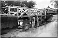
Ford across the Ash at Hadham Cross, 1971
This shot from 2009 http://www.geograph.org.uk/photo/337302 shows the somewhat rickety footbridge was rebuilt at some point.
Image: © Penny Mayes
Taken: 1 Jan 1971
0.09 miles
4
Ford over River Ash, Much Hadham
Taken from Maltings Lane (foreground) and shows Oudle Lane (left) and Danesbridge Road (right).
Image: © David Kemp
Taken: 12 Nov 2022
0.09 miles
5
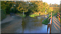
Ford at Hadham Cross
This is the first of the two fords at Hadham Cross found on the T junction on Maltings Lane.
http://www.youtube.com/watch?v=XCJDjMPBPF8
Image: © John Walton
Taken: 17 Mar 2013
0.09 miles
6
Ford at junction, Hadham Cross
Crossing the River Ash.
Image: © Robin Webster
Taken: 13 Mar 2014
0.09 miles
7
Much Hadham
Ash Meadow looking towards the High street
Image: © Raymond Cubberley
Taken: 19 Jul 2011
0.09 miles
8
Ford at Hadham Cross
At the time of the shot, the river had overflowed and the minor road leading to Danebridge Road on the left of the picture was closed
Image: © John Smith
Taken: 13 Feb 2007
0.10 miles
9
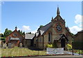
Congregational Church, Hadham Cross, Much Hadham
Dates from 1872-1874 and designed by Habershon & Brock.
Image: © JThomas
Taken: 20 Jul 2019
0.10 miles
10
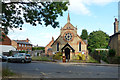
Hadham Cross Congregational Church
The small fire station is directly across the road.
Image: © Robin Webster
Taken: 25 Jun 2015
0.10 miles