IMAGES TAKEN NEAR TO
MUCH HADHAM, SG10 6AU
Introduction
This page details the photographs taken nearby to SG10 6AU by members of the Geograph project.
The Geograph project started in 2005 with the aim of publishing, organising and preserving representative images for every square kilometre of Great Britain, Ireland and the Isle of Man.

There are currently over 7.5m images from over14,400 individuals and you can help contribute to the project by visiting https://www.geograph.org.uk
Image Map (Loading...)


Getting Data...Please wait
Leaflet Map data © OpenStreetMap
Images are licensed for reuse under creativecommons.org/licenses/by-sa/2.0
Notes
- Clicking on the map will re-center to the selected point.
- The higher the marker number, the further away the image location is from the centre of the postcode.
Image Listing (8 Images Found)
Images are licensed for reuse under creativecommons.org/licenses/by-sa/2.0
Image
Details
Distance
1
Site of Hadham station
View NW on Station Road: ex-GER St Margarets (to right) - (to left) Buntingford branch. There is no trace of the station, which was closed with the line from 16/11/64, although goods traffic continued until 20/9/65.
The station was demolished by British Railways after massive vandalism took place after closure.
Further information on the station and the branch line can be found at http://www.disused-stations.org.uk/h/hadham/index.shtml.
Image: © Ben Brooksbank
Taken: 22 Jun 1995
0.03 miles
2
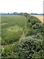
Field and path entrance on Kettle Green Road
Image: © David Howard
Taken: 16 Feb 2016
0.16 miles
4
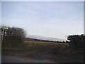
Disappearing Railway
View from the railway bridge on Kettle Green Road towards the site of Hadham station on the Ware, Hadham and Buntingford Railway. The railway opened in 1863 and final closed in 1965. The trackbed has entirely disappeared under the plough here though the hedge probably marks the southwestern side of the line. Much of the rest of the route can be traced on maps and satellite photographs.
Image: © Martin Addison
Taken: 4 Jul 2006
0.21 miles
5
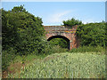
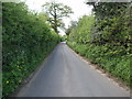
Kettle Green Bridge
View from the trackbed looking northwest at the bridge carrying Kettle Green Road over the dismantled Ware, Hadham and Buntingford Railway. The parapet brickwork is starting to crumble.
Image: © Martin Addison
Taken: 4 Jul 2006
0.21 miles
6
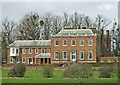
Moor Place, Much Hadham, Hertfordshire
Image: © Christine Matthews
Taken: 31 Mar 2006
0.24 miles
7
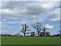
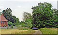
Old Oak Trees in field near Moor Place, Much Hadham, Hertfordshire
This row of old oak trees is a landmark near Moor Place, Much Hadham, Hertfordshire.
Image: © Christine Matthews
Taken: 31 Mar 2006
0.24 miles
8
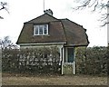
Dell Cottage near Moor Place, Much Hadham, Hertfordshire
Image: © Christine Matthews
Taken: 31 Mar 2006
0.24 miles