IMAGES TAKEN NEAR TO
Mulberry Place, Pinnell Road, LONDON, SE9 6AR
Introduction
This page details the photographs taken nearby to Mulberry Place, Pinnell Road, SE9 6AR by members of the Geograph project.
The Geograph project started in 2005 with the aim of publishing, organising and preserving representative images for every square kilometre of Great Britain, Ireland and the Isle of Man.

There are currently over 7.5m images from over14,400 individuals and you can help contribute to the project by visiting https://www.geograph.org.uk
Image Map
Images are licensed for reuse under creativecommons.org/licenses/by-sa/2.0
Notes
- Clicking on the map will re-center to the selected point.
- The higher the marker number, the further away the image location is from the centre of the postcode.
Image Listing (36 Images Found)
Images are licensed for reuse under creativecommons.org/licenses/by-sa/2.0
Image
Details
Distance
1
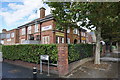
Real Life Church, Eltham
It describes itself as non-denominational and multi-national.
Image: © Bill Boaden
Taken: 11 Oct 2014
0.04 miles
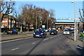
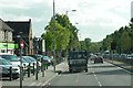
2
Westhorne Avenue at the junction with the A2
Image: © David Howard
Taken: 18 May 2014
0.05 miles
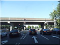
3
Traffic lights on Westhorne Avenue
This is part of the South Circular Road, about to go under a railway and the A2.
Image: © Bill Boaden
Taken: 11 Oct 2014
0.05 miles
4
Slip Road to South Circular Road
The sliproad from the southbound A2 to the South Circular Road (A205).
Image: © David Dixon
Taken: 15 May 2013
0.06 miles
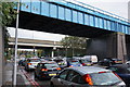
5
A205 Westhorne Avenue
The blue bridge in the background carries the railway over the South Circular Road. It hides an adjacent bridge which carries the A2.
Image: © David Martin
Taken: 19 Jan 2020
0.07 miles
6
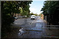
Briset Road, Eltham
The road is blocked off at the end where it meets the South Circular Road.
Image: © Bill Boaden
Taken: 11 Oct 2014
0.08 miles
7
Briset Park
This small park was somewhat reduced in size when the Rochester Way Relief Road opened in 1988 through Kidbrooke and Eltham. Before that the southern boundary of the park was the Bexleyheath railway line.
Image: © Marathon
Taken: 22 Jan 2021
0.09 miles
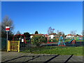
8
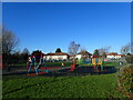
Briset Park
This small park was somewhat reduced in size when the Rochester Way Relief Road opened in 1988 through Kidbrooke and Eltham. Before that the southern boundary of the park was the Bexleyheath railway line.
Image: © Marathon
Taken: 22 Jan 2021
0.09 miles
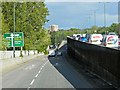
10
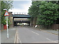
Shawbrooke Road, near Eltham
Bridges across Shawbrooke Road near Eltham in south east London. The bridge nearest the camera carries a railway line. The concrete bridge behind it carries the trunk A2 road.
The road bridge has a height limit of 12 feet, as indicated by the warning signs. There is also a width restriction near the bridge, to prevent lorries from using this road.
Image: © Malc McDonald
Taken: 14 Jul 2019
0.09 miles