IMAGES TAKEN NEAR TO
Churchbury Road, LONDON, SE9 5HU
Introduction
This page details the photographs taken nearby to Churchbury Road, SE9 5HU by members of the Geograph project.
The Geograph project started in 2005 with the aim of publishing, organising and preserving representative images for every square kilometre of Great Britain, Ireland and the Isle of Man.

There are currently over 7.5m images from over14,400 individuals and you can help contribute to the project by visiting https://www.geograph.org.uk
Image Map
Images are licensed for reuse under creativecommons.org/licenses/by-sa/2.0
Notes
- Clicking on the map will re-center to the selected point.
- The higher the marker number, the further away the image location is from the centre of the postcode.
Image Listing (55 Images Found)
Images are licensed for reuse under creativecommons.org/licenses/by-sa/2.0
Image
Details
Distance
1

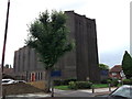
St Saviour's church, Middle Park, Eltham
Unusually for a 20th century brick church, this one by the architect Cachemaille-Day is listed (list entry number 1212904). It was one of twenty-five new churches built in the inter-war period by Southwark Diocese to serve growing housing estates.
The flagpole shown here can indeed be used for flying a flag but is primarily a mobile phone mast, and was added in 2011.
Image: © Stephen Craven
Taken: 2 Oct 2011
0.05 miles
2
The Parish Church of St. Saviour, Eltham
Dark sombre bricked church on the junction of Middle Park Avenue (in front) and Gregory Drive (unseen, on the right).
Image: © David Anstiss
Taken: 18 Sep 2011
0.06 miles
3
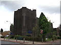
The Parish Church of St. Saviour, Eltham
Dark sombre, Grade II listed church on the junction of Middle Park Avenue (on the left) and Gregory Drive (on the right).
See http://www.britishlistedbuildings.co.uk/en-397441-church-of-st-saviours-eltham for more details about the church
Image: © David Anstiss
Taken: 18 Sep 2011
0.06 miles
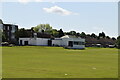
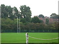
5
Sports ground east of Sidcup Road, SE9 (2)
The Quaggy River runs in the trees on the far side of the grounds.
Image: © Mike Quinn
Taken: 23 Sep 2010
0.11 miles
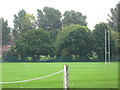
10
Sports ground east of Sidcup Road, SE9
The Quaggy River runs in the trees on the far side of the grounds.
Image: © Mike Quinn
Taken: 23 Sep 2010
0.13 miles