IMAGES TAKEN NEAR TO
Silverdale Drive, LONDON, SE9 4DH
Introduction
This page details the photographs taken nearby to Silverdale Drive, SE9 4DH by members of the Geograph project.
The Geograph project started in 2005 with the aim of publishing, organising and preserving representative images for every square kilometre of Great Britain, Ireland and the Isle of Man.

There are currently over 7.5m images from over14,400 individuals and you can help contribute to the project by visiting https://www.geograph.org.uk
Image Map
Images are licensed for reuse under creativecommons.org/licenses/by-sa/2.0
Notes
- Clicking on the map will re-center to the selected point.
- The higher the marker number, the further away the image location is from the centre of the postcode.
Image Listing (51 Images Found)
Images are licensed for reuse under creativecommons.org/licenses/by-sa/2.0
Image
Details
Distance
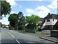
4
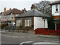
House of an earlier era
Standing out in a street of suburban semis is this little bungalow, that maps suggest is at least early Victorian. It is on Court Farm Road and may have been associated with that farm when it existed.
Image: © Robin Webster
Taken: 4 Feb 2012
0.08 miles
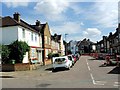
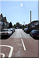
5
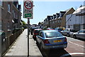
Dorset Road Mottingham
This end of the road has a number of newly built houses and apartments. The other end of the road retains its late Victorian terraces. The white building on the right used to be Scotts Renault garage. Now it is home to a branch of Albins funeral directors.
Image: © Martin Kerans
Taken: 30 May 2009
0.09 miles
6
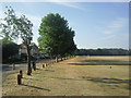
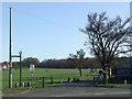
Mottingham Sports Ground and Court Farm Road
Court Farm Road runs along the eastern side of Mottingham Sports Ground. This wide open space leads up to Lower Marvels Wood and is crossed by the Green Chain Walk.
Image: © Marathon
Taken: 3 Aug 2010
0.09 miles
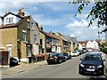
7
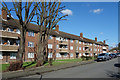
John Hunt Court
Local authority housing along Clarence Road, Mottingham.
Image: © Des Blenkinsopp
Taken: 6 Mar 2020
0.11 miles
8
Green Chain Walk through Mottingham
The Green Chain Walk is a walking route linking green open spaces across South East London. The signpost to the left of the image points the way here, as it crosses a sports field in Mottingham.
Image: © Malc McDonald
Taken: 19 Mar 2011
0.12 miles
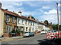
9
Devonshire Road, Mottingham
Most of these houses would date from the late Victorian period but there is something special at the far end of the road.
Image: © Martin Kerans
Taken: 30 May 2009
0.12 miles