IMAGES TAKEN NEAR TO
Dittisham Road, LONDON, SE9 4BH
Introduction
This page details the photographs taken nearby to Dittisham Road, SE9 4BH by members of the Geograph project.
The Geograph project started in 2005 with the aim of publishing, organising and preserving representative images for every square kilometre of Great Britain, Ireland and the Isle of Man.

There are currently over 7.5m images from over14,400 individuals and you can help contribute to the project by visiting https://www.geograph.org.uk
Image Map
Images are licensed for reuse under creativecommons.org/licenses/by-sa/2.0
Notes
- Clicking on the map will re-center to the selected point.
- The higher the marker number, the further away the image location is from the centre of the postcode.
Image Listing (22 Images Found)
Images are licensed for reuse under creativecommons.org/licenses/by-sa/2.0
Image
Details
Distance
1
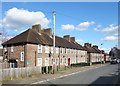
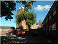
Chilham Road, Mottingham
So many chimneys. No wonder there was smog in the bad old days.
Image: © Des Blenkinsopp
Taken: 6 Mar 2020
0.06 miles
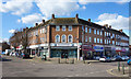
2
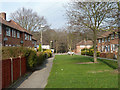
Kimmeridge Road, Mottingham
The Mottingham Estate is a 2,000 home housing estate developed in the 1930s by the London County Council. As well as housing, the estate included facilities such as shops and a church, both visible in this image.
Image: © Malc McDonald
Taken: 19 Mar 2011
0.08 miles
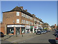
3
Shops at the Cross Roads
Neighbourhood shops and services are on the four corners where Beaconsfield and Kimmeridge roads cross.
Image: © Des Blenkinsopp
Taken: 6 Mar 2020
0.09 miles
4
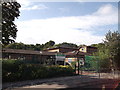
Castlecombe Primary School
On Castlecombe Road.
In the background is Elmstead Wood.
Image: © David Anstiss
Taken: 18 Sep 2011
0.11 miles
5
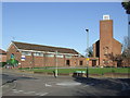
St Edward the Confessor, Mottingham SE9
Built in 1957, the church stands opposite the junction with St Keverne Road and Kimmeridge Road and is flanked by the church hall (left) and vicarage (right).
Image: © Philip Talmage
Taken: 4 Nov 2005
0.11 miles
6
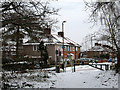
Castlecombe Road, Mottingham
The gate from Castlecombe Road into Elmstead Woods.
Image: © Stephen Craven
Taken: 9 Jan 2010
0.14 miles
7
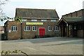
Court Farm Evangelist church hall
There is a 'Christian playgroup' held here on Thursday mornings in school term time only, according to the banner.
Image: © Robin Webster
Taken: 4 Feb 2012
0.15 miles
8
Green Chain Walk on Charminster Road
The long distance path heads down Calcott Walk towards Castleton Road and onwards to Lower Marvels Wood. The path also heads right to Castlecombe Road to enter Elmstead Woods.
Note:The Green Chain Signpost is incorrect!
Image: © David Anstiss
Taken: 18 Sep 2011
0.15 miles
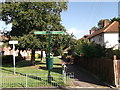
9
Calcott Walk
Lower Marvels Wood is across the road ahead.
Image: © Robin Webster
Taken: 4 Feb 2012
0.16 miles
10
Church of St. Edward the Confessor, Mottingham
The road is named St. Keverne Road, but the church is named after St. Edward the Confessor.
Image: © Malc McDonald
Taken: 19 Mar 2011
0.17 miles