IMAGES TAKEN NEAR TO
Aldwick Close, LONDON, SE9 3UE
Introduction
This page details the photographs taken nearby to Aldwick Close, SE9 3UE by members of the Geograph project.
The Geograph project started in 2005 with the aim of publishing, organising and preserving representative images for every square kilometre of Great Britain, Ireland and the Isle of Man.

There are currently over 7.5m images from over14,400 individuals and you can help contribute to the project by visiting https://www.geograph.org.uk
Image Map
Images are licensed for reuse under creativecommons.org/licenses/by-sa/2.0
Notes
- Clicking on the map will re-center to the selected point.
- The higher the marker number, the further away the image location is from the centre of the postcode.
Image Listing (40 Images Found)
Images are licensed for reuse under creativecommons.org/licenses/by-sa/2.0
Image
Details
Distance
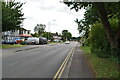
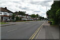
2
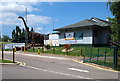
Sidcup By-Pass, New Eltham, SE9
With residential housing in Aldwick Close providing a backdrop, this is a view of the bypass (the A211) as it heads towards Sidcup (which it skirts on this suburb's southern side).
Image: © David Hallam-Jones
Taken: 17 Jun 2014
0.04 miles
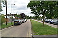
7
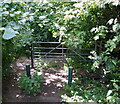
Kemnal Road, Chislehurst, Kent
The entrance to Kemnal Road from the Chislehurst side of the northbound carriageway of the Sidcup By-Pass (the A211). In reality, the designation 'road' is something of a misnomer here because at this entrance/exit point it has become nothing more than an unmade, poorly maintained rural footpath. The road (proper) commences several miles away in Chislehurst as a C category road, that then becomes a D category road, before petering out here. The pavement that runs along the southern side of the by-pass is just 'steps' away behind the photographer. Old records show that the road was established as a private road in approximately 1871.
Image: © David Hallam-Jones
Taken: 17 Jun 2014
0.06 miles
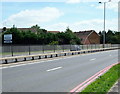
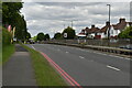
8
Sidcup By-pass, New Eltham SE9
A view of the northbound (London-bound) carriageway of the A211 with houses situated in Aldwick Close opposite. This side of the road is part of Chislehurst. At the foot of the picture is the entrance/exit into and out of Kemnal Road, although in fact the designation 'road' is something of a misnomer here. In reality Kemnal Road (proper) - that commences several miles away in Chislehurst - has, at this point, become nothing more than an unmade, poorly maintained rural footpath. Most of this extremely long road (perhaps 3-4 miles in length in total) is a C category road that later becomes a D category road, before petering out a mile or so behind the photographer. At this northerly end it becomes a track and then an uncared-for footpath. Records show that the road was established as a private road in approximately 1871.
Image: © David Hallam-Jones
Taken: 17 Jun 2014
0.06 miles
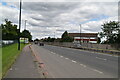
9
Sidcup By-Pass, Chislehurst, Kent
The entrance to the 6.07 hectares (15 acres) “World of Golf” site off the northbound carriageway of the Sidcup By Pass (the A20), Chislehurst, Kent. Planning permission was granted some time ago (date unknown) here for the importation of recovered material to construct a mini masters 5 hole golf course, a fishing lake, an adventure playground, an adventure-themed putting course, a cafe/ bar and a golf superstore. Ashtour Ltd also received planning permission for twelve 5 a-side football pitches.
Image: © David Hallam-Jones
Taken: 17 Jun 2014
0.07 miles
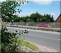
10
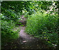
Kemnal Road, Chislehurst, Kent
Kemnal Road, a 3 or 4 mile long road commences (or ends) here as an overgrown, uncared-for rural footpath close to the northbound (London bound) carriageway of the Sidcup By-Pass (the A211). The latter is 2-3 minutes walk behind the photographer. Several miles ahead it becomes a D category road and then later a C category road, before finally reaching central Chislehurst.
Image: © David Hallam-Jones
Taken: 17 Jun 2014
0.08 miles