IMAGES TAKEN NEAR TO
Green Lane, LONDON, SE9 3TD
Introduction
This page details the photographs taken nearby to Green Lane, SE9 3TD by members of the Geograph project.
The Geograph project started in 2005 with the aim of publishing, organising and preserving representative images for every square kilometre of Great Britain, Ireland and the Isle of Man.

There are currently over 7.5m images from over14,400 individuals and you can help contribute to the project by visiting https://www.geograph.org.uk
Image Map
Images are licensed for reuse under creativecommons.org/licenses/by-sa/2.0
Notes
- Clicking on the map will re-center to the selected point.
- The higher the marker number, the further away the image location is from the centre of the postcode.
Image Listing (10 Images Found)
Images are licensed for reuse under creativecommons.org/licenses/by-sa/2.0
Image
Details
Distance
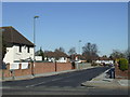
1
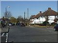
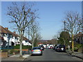
Domonic Drive, New Eltham
Domonic Drive is a residential road. Telephone wires are still above ground, attached to the telegraph pole on the other side of the road.
Image: © Malc McDonald
Taken: 19 Mar 2011
0.09 miles
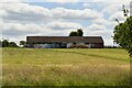
3
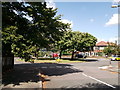
Roundabout on Crouch Croft
Crouch Croft leads from Beanshaw (road) towards William Barefoot Drive.
Coleman's Heath leads right towards Green Lane.
On the right is a large recreational ground.
Image: © David Anstiss
Taken: 15 Aug 2011
0.18 miles
5
Domonic Drive, New Eltham
Domonic Drive is a residential road. At the time this photo was taken, telephone wires were still above ground, attached to the tall post on the opposite side of the road.
Image: © Malc McDonald
Taken: 19 Mar 2011
0.19 miles
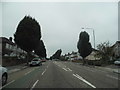
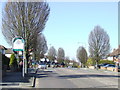
6
Green Lane at the borough boundary
Looking from Bromley into Greenwich as Green Lane descends towards New Eltham.
Image: © David Martin
Taken: 26 Feb 2023
0.20 miles
7
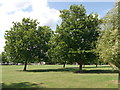
Trees in Crouch Croft Recreational Ground
This large ground is between Crouch Croft and The Course.
Image: © David Anstiss
Taken: 15 Aug 2011
0.21 miles
9
Edgebury, Chislehurst
Edgebury is a residential road in Chislehurst.
Image: © Malc McDonald
Taken: 19 Mar 2011
0.22 miles
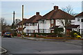
10
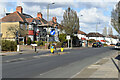
Borough Boundary near Chislehurst
Chislehurst is within the London Borough of Bromley. It is not far from the boundary with the London Borough of Greenwich, which is marked by the sign to the left of the road. This photo was taken on Green Lane.
Image: © Malc McDonald
Taken: 19 Mar 2011
0.22 miles