IMAGES TAKEN NEAR TO
Biddenden Way, LONDON, SE9 3DN
Introduction
This page details the photographs taken nearby to Biddenden Way, SE9 3DN by members of the Geograph project.
The Geograph project started in 2005 with the aim of publishing, organising and preserving representative images for every square kilometre of Great Britain, Ireland and the Isle of Man.

There are currently over 7.5m images from over14,400 individuals and you can help contribute to the project by visiting https://www.geograph.org.uk
Image Map
Images are licensed for reuse under creativecommons.org/licenses/by-sa/2.0
Notes
- Clicking on the map will re-center to the selected point.
- The higher the marker number, the further away the image location is from the centre of the postcode.
Image Listing (50 Images Found)
Images are licensed for reuse under creativecommons.org/licenses/by-sa/2.0
Image
Details
Distance
5
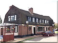
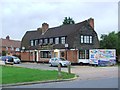
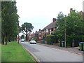
The Farmhouse Public House, Chislehurst
On the junction of Beanshaw (on the left) and The Knole (behind the pub).
Image: © David Anstiss
Taken: 15 Aug 2011
0.08 miles
6
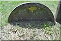
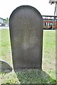
Old Boundary Marker by the A208, Mottingham Road, Eltham Parish
Municipal Boundary Marker by the A208, in parish of Eltham (Greenwich District), Mottingham Road, at junction with William Barefoot Drive on grass open space in front of No.3 Swithland gardens. Adjacent to: KE_WOOLB02pb Image
Surveyed
Milestone Society National ID: KE_WOOLB03pb
Image: © Milestone Society
Taken: Unknown
0.08 miles
7
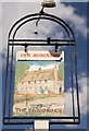
The Farmhouse Pub Sign
On a small green in front of Image
Image: © David Anstiss
Taken: 15 Aug 2011
0.08 miles
9
Old Boundary Marker by the A208, Whitehorse Hill, Eltham Parish
Municipal Boundary Marker by the A208, Whitehorse Hill, in parish of Eltham (Greenwich District), West of Swithland Gardens, near the junction with William Barefoot Drive, on grass open space in front of #3 Swithland Gardens.
Surveyed
Milestone Society National ID: KE_WOOLB02pb
Image: © Milestone Society
Taken: Unknown
0.09 miles