IMAGES TAKEN NEAR TO
Bexley Road, LONDON, SE9 2PT
Introduction
This page details the photographs taken nearby to Bexley Road, SE9 2PT by members of the Geograph project.
The Geograph project started in 2005 with the aim of publishing, organising and preserving representative images for every square kilometre of Great Britain, Ireland and the Isle of Man.

There are currently over 7.5m images from over14,400 individuals and you can help contribute to the project by visiting https://www.geograph.org.uk
Image Map
Images are licensed for reuse under creativecommons.org/licenses/by-sa/2.0
Notes
- Clicking on the map will re-center to the selected point.
- The higher the marker number, the further away the image location is from the centre of the postcode.
Image Listing (37 Images Found)
Images are licensed for reuse under creativecommons.org/licenses/by-sa/2.0
Image
Details
Distance
1
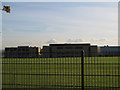
Site of the former Crown Woods School
The original school buildings were on what is now this open sports field: see Image three years earlier. The new Crown Woods College buildings are beyond.
This photo is taken over the top of the outer security fence, which is why I could not get close enough to the inner fence to take a photo through it.
Image: © Stephen Craven
Taken: 18 Nov 2012
0.07 miles
2
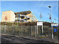
Crown Woods College - new building
One of several new buildings comprising the relaunched school www.crownwoods.org.uk that opened in 2011. The old school was situated at the north end of the site, and has now been demolished Image
Image: © Stephen Craven
Taken: 18 Nov 2012
0.09 miles
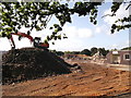
3
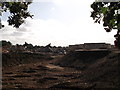
New College, Old School, Crown Woods
As seen from Gravel Pit Lane.
This large school (on the left) on Bexley Road, has been demolished.
Large piles of rubble and metalwork are waiting to be removed from the site.
The school has been converted into a college, under the 'Building Schools for the Future' initiative. The new buildings (on the right) are closer to Bexley Road.
See http://www.crownwoods.org.uk/?q=node/19 for more details
Image: © David Anstiss
Taken: 11 Sep 2011
0.09 miles
4
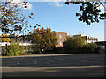
Crown Woods school
A co-educational comprehensive school in Eltham. The buildings are seen here from the public footpath round the back of the school and the photo was taken at a weekend, hence no pupils around.
Image shows the scene after these buildings had been demolished in 2011.
Image: © Stephen Craven
Taken: 25 Oct 2009
0.10 miles
5
Virtually demolished Crown Woods School
As seen from Gravel Pit Lane.
This large school on Bexley Road, has been demolished.
Large piles of brick and rubble are waiting to be removed from the site.
The school has been converted into a college, under the 'Building Schools for the Future' initiative. The new buildings are closer to Bexley Road.
Image: © David Anstiss
Taken: 11 Sep 2011
0.10 miles
6
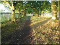
Early morning on Gravel Pit Lane
Gravel Pit Lane is an old trackway linking Riefield Road and Bexley Road. Eltham Warren Golf Course is on the right here and the grounds of Crown Woods School are on the left. This photograph was taken soon after the sun had risen.
Image: © Marathon
Taken: 15 Sep 2012
0.12 miles
7
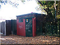
Electricity substation behind Riefield Road
Image: © Stephen Craven
Taken: 25 Oct 2009
0.12 miles
8
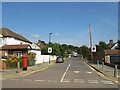
Colepits Wood Road, Falconwood
Colepits Wood Road is a residential road in Falconwood, in the outer suburbs of south east London.
Image: © Malc McDonald
Taken: 18 Sep 2021
0.12 miles
9
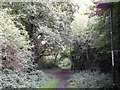
Gravel Pit Lane to Bexley Road
The Green Chain Walk (long distance path) leads from Riefield Road, past Elham Warren Golf Course (on the right) and Elham Warren Nature Reserve (on the left).
Image: © David Anstiss
Taken: 11 Sep 2011
0.12 miles
10
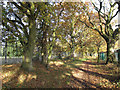
Woodland corridor
The mature trees either side of the Green Chain Walk at this point form a narrow corridor between two open spaces: the golf course to the left, and the sports files of Crown Woods College to the right.
Image: © Stephen Craven
Taken: 18 Nov 2012
0.13 miles