IMAGES TAKEN NEAR TO
Restons Crescent, LONDON, SE9 2JH
Introduction
This page details the photographs taken nearby to Restons Crescent, SE9 2JH by members of the Geograph project.
The Geograph project started in 2005 with the aim of publishing, organising and preserving representative images for every square kilometre of Great Britain, Ireland and the Isle of Man.

There are currently over 7.5m images from over14,400 individuals and you can help contribute to the project by visiting https://www.geograph.org.uk
Image Map
Images are licensed for reuse under creativecommons.org/licenses/by-sa/2.0
Notes
- Clicking on the map will re-center to the selected point.
- The higher the marker number, the further away the image location is from the centre of the postcode.
Image Listing (48 Images Found)
Images are licensed for reuse under creativecommons.org/licenses/by-sa/2.0
Image
Details
Distance
1
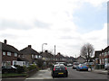
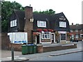
Restons Crescent, Eltham
Typical of the large amount of inter-war housing in this part of south-east London.
Image: © Stephen Craven
Taken: 6 Apr 2015
0.02 miles
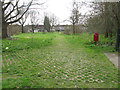
3
Path to Restons Crescent
The photographer position is on the Greenwich/Bexley borough border. This is the view looking into Greenwich. The area to the left of the footpath appears to be surfaced with "grasscrete", presumably to prevent it becoming too muddy. This is actually the most successful example of Grasscrete I have seen, normally very little grass actually grows. The path itself forms part of the Shuttle Riverway.
Image: © Stephen Craven
Taken: 6 Apr 2015
0.04 miles
4
Path to Norfolk Crescent
The photographer position is on the Greenwich/Bexley borough border. This is the view looking into Bexley. The footpath appears to be surfaced with "grasscrete", presumably to prevent it becoming too muddy. Shortly before the houses on Norfolk Crescent in the background the path crosses the minor river Shuttle.
Image: © Stephen Craven
Taken: 6 Apr 2015
0.05 miles
5
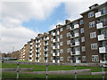
Linsted Court, Restons Crescent, Eltham
A pair of five-storey blocks of flats on the east side of the road.
Image: © Stephen Craven
Taken: 6 Apr 2015
0.07 miles
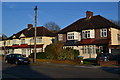
6
Looking towards flats in Restons Crescent
Image: © David Martin
Taken: 19 Apr 2019
0.09 miles
8
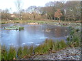
The pond in Parish Wood Park
The park is called after Parish Wood which forms the north-eastern part of it. Parish Wood was just over the old London County boundary into Kent. The pond had only recently been created but is already settling in as a feature of the park. Although sunny it was very cold so that the frost in the shade had still not melted by lunchtime.
See http://walkaroundlondon.com/the-sunny-shuttle-riverway-and-a-bit-more/ for an account of a walk along the Shuttle Riverway.
Image: © Marathon
Taken: 17 Jan 2013
0.10 miles
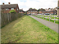
9
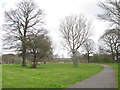
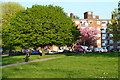
Parish Wood Park
A small park in the western end of Bexley borough, refurbished in recent years. The path is part of the Shuttle Riverway.
Image: © Stephen Craven
Taken: 6 Apr 2015
0.10 miles
10
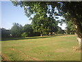
Parish Wood Park
The park is called after Parish Wood which forms the north-eastern part of it. Parish Wood was just over the old London County boundary into Kent. The infant River Shuttle flows in the far distance on the right.
See http://walkaroundlondon.com/the-sunny-shuttle-riverway-and-a-bit-more/ for an account of a walk along the Shuttle Riverway.
Image: © Marathon
Taken: 4 Jul 2010
0.10 miles