IMAGES TAKEN NEAR TO
Clayton Drive, LONDON, SE8 5RL
Introduction
This page details the photographs taken nearby to Clayton Drive, SE8 5RL by members of the Geograph project.
The Geograph project started in 2005 with the aim of publishing, organising and preserving representative images for every square kilometre of Great Britain, Ireland and the Isle of Man.

There are currently over 7.5m images from over14,400 individuals and you can help contribute to the project by visiting https://www.geograph.org.uk
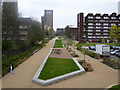
Image Map
Images are licensed for reuse under creativecommons.org/licenses/by-sa/2.0
Notes
- Clicking on the map will re-center to the selected point.
- The higher the marker number, the further away the image location is from the centre of the postcode.
Image Listing (78 Images Found)
Images are licensed for reuse under creativecommons.org/licenses/by-sa/2.0
Image
Details
Distance
1
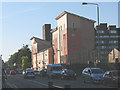
New residential block on Evelyn Street
A comparison of this with Image a few hundred metres further along the street illustrates the changing face of Deptford as industry is slowly replaced with housing - nearly all of it in the form of student blocks or 'luxury' apartments.
Image: © Stephen Craven
Taken: 19 Aug 2009
0.03 miles
2
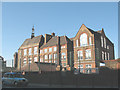
Deptford Park School
Typical of the style of 19th century schools in this area.
Image: © Stephen Craven
Taken: 19 Aug 2009
0.04 miles
3
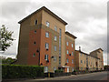
Frobisher Court, Deptford
This block, built c.2008, consists of three parts, from this end called Frobisher Court, Cook Court and Trinity Court.
Image: © Stephen Craven
Taken: 19 Apr 2014
0.04 miles
4
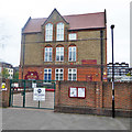
Deptford Park Primary School
On Oxestalls Road, SE8.
Image: © Robin Webster
Taken: 6 Apr 2019
0.04 miles
5
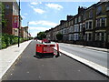
Blocked cycle lane beside Evelyn Street (A200)
Looking south east - Deptford, London, SE8.
Image: © JThomas
Taken: 20 Jun 2022
0.04 miles
6
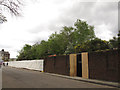
Rainsborough Avenue, Deptford
Behind the sheeting a Barratt housing development was just starting. The trees behind are growing on the embankment that once carried a railway into Deptford Wharf (closed 1964).
Image: © Stephen Craven
Taken: 19 Apr 2014
0.07 miles
7
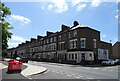
Houses on Evelyn Street (A200)
Deptford, London, SE8.
Image: © JThomas
Taken: 20 Jun 2022
0.08 miles
8
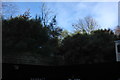
Rainsborough Avenue
The embankment and bridge abutment are the remains of the Deptford Wharf branch line. A freight only route to the docks that closed in 1964
Image: © Robert Eva
Taken: 10 Jan 2016
0.08 miles
9
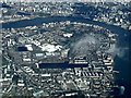
Rotherhithe from the air
Greenland Dock is prominent in the centre. Taken from a Heathrow bound flight from Glasgow.
Image: © Thomas Nugent
Taken: 18 Mar 2014
0.08 miles
10
Course of Grand Surrey Canal
Looking towards where it entered the Surrey Docks.
Image: © Robin Webster
Taken: 6 Apr 2019
0.09 miles