IMAGES TAKEN NEAR TO
Glenville Grove, LONDON, SE8 4BP
Introduction
This page details the photographs taken nearby to Glenville Grove, SE8 4BP by members of the Geograph project.
The Geograph project started in 2005 with the aim of publishing, organising and preserving representative images for every square kilometre of Great Britain, Ireland and the Isle of Man.

There are currently over 7.5m images from over14,400 individuals and you can help contribute to the project by visiting https://www.geograph.org.uk
Image Map
Images are licensed for reuse under creativecommons.org/licenses/by-sa/2.0
Notes
- Clicking on the map will re-center to the selected point.
- The higher the marker number, the further away the image location is from the centre of the postcode.
Image Listing (170 Images Found)
Images are licensed for reuse under creativecommons.org/licenses/by-sa/2.0
Image
Details
Distance
1
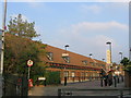
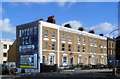
Albany Theatre, Deptford
A modern theatre and community centre just off Deptford High Street.
Image: © Stephen Craven
Taken: 15 Oct 2006
0.06 miles
2
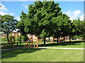
Margaret Macmillan Park, redeveloped (1)
The park was redeveloped by Lewisham Council in the first half of 2010. This is the eastern end of the park adjacent to Douglas Way. The purpose of the different height wooden posts is unclear.
Image: © Stephen Craven
Taken: 28 May 2010
0.06 miles
3
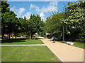
Margaret Macmillan Park, Deptford
One of several green spaces left in the redevelopment of Deptford. This path is part of the London Cycle Network.
Image: © Stephen Craven
Taken: 15 Oct 2006
0.07 miles
4
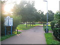
Margaret Macmillan Park, redeveloped (2)
This is essentially the same view as Image in 2006. The linear park along the line of Douglas Way was redeveloped in the first half of 2010.
Image: © Stephen Craven
Taken: 28 May 2010
0.07 miles
5
Ghost Sign for Lipton's Tea
A large old painted advert on an end of terrace wall on the corner of Mornington Road.
"The finest the world produces" it says underneath, which sounds somehow old fashioned as well.
I wonder what happened to the L .
Image: © Des Blenkinsopp
Taken: 6 Mar 2020
0.07 miles
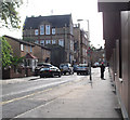
7
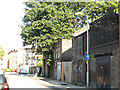
Stanley Street, New Cross
Much of the Deptford/New Cross area has already been redeveloped, but in this back street there are a couple of run-down brick buildings probably dating from the 19th century or earlier.
Image: © Stephen Craven
Taken: 1 Jun 2009
0.08 miles
8
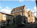
The Mornington Centre, Stanley Street, New Cross
A local authority education centre. It was the focus of a local media story in April 2009 when children were transferred here from Lewisham Bridge School some distance away, to the anger of parents. http://defendeducationlewisham.wordpress.com/
Geograph member John Webb recalls, "This building was the Upper School when I knew it in 1959-1964 - did my 'O' and 'A' levels here. The lower school was near St John's Station in TQ3776. It had the 'Technical' removed from the name at some point during my stay here - I don't know precisely why!"
Image: © Stephen Craven
Taken: 1 Jun 2009
0.08 miles
9

Deptford market, Douglas Way
There is a market at the east end of Douglas Way on Wednesdays and Fridays, but on Saturdays it stretches the full length of the street.
Image: © Stephen Craven
Taken: 10 Dec 2011
0.09 miles
10
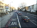
A2 New Cross Road
The best way to view this normally very busy road, and certainly the safest way to photograph it, is from the top deck of a bus. On a Sunday afternoon the traffic was light compared to a weekday rush hour but one pedestrian can be seen still having difficulty finding space to cross! The road to the left is Mornington Road.
Image: © Stephen Craven
Taken: 18 Jan 2015
0.09 miles