IMAGES TAKEN NEAR TO
Grove Street, LONDON, SE8 3PG
Introduction
This page details the photographs taken nearby to Grove Street, SE8 3PG by members of the Geograph project.
The Geograph project started in 2005 with the aim of publishing, organising and preserving representative images for every square kilometre of Great Britain, Ireland and the Isle of Man.

There are currently over 7.5m images from over14,400 individuals and you can help contribute to the project by visiting https://www.geograph.org.uk
Image Map
Images are licensed for reuse under creativecommons.org/licenses/by-sa/2.0
Notes
- Clicking on the map will re-center to the selected point.
- The higher the marker number, the further away the image location is from the centre of the postcode.
Image Listing (138 Images Found)
Images are licensed for reuse under creativecommons.org/licenses/by-sa/2.0
Image
Details
Distance
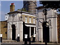
2
Riverside Youth Club
On the corner of Grove Street and Oxestalls Road, SE8.
Image: © Robin Webster
Taken: 6 Apr 2019
0.04 miles
4
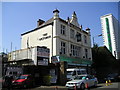
The Victoria Pub (closed), Deptford
Grove Street, Deptford, LONDON SE8 3QQ close to The River Thames Tideway
Image: © canalandriversidepubs co uk
Taken: 23 Apr 2010
0.06 miles
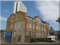
5
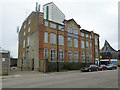
Scott House, Grove Street (B206), SE8
It appears to be flats now, but evidently was originally the premises of A.G. Scott and Co. Ltd. They were manufacturers of plain and decorated tin boxes.
Image: © Robin Webster
Taken: 6 Apr 2019
0.06 miles
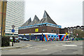
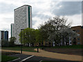
6
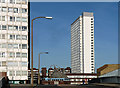
Pepys Estate, Grove Street
The two towers seen from Oxestalls Road. The estate was built by the London County Council in 1963-66.
A third tower was "privatised", as explained here: Image
Image: © Stephen Richards
Taken: 1 Apr 2012
0.08 miles
8
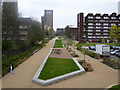
Course of Grand Surrey Canal
Looking towards where it entered the Surrey Docks.
Image: © Robin Webster
Taken: 6 Apr 2019
0.08 miles
9
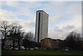
Daubeney Tower, Deptford
This is a view of the tower from a riverside park to the east. It is also seen from different angles in Image and Image
Image: © Stephen Craven
Taken: 2 Apr 2011
0.09 miles
10
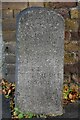
Old Boundary Marker on Grove Street, Deptford
Turnpike Terminus Marker against the brick wall of 1-8 The Colonnade on the east side of the B206 Grove Street, Deptford SE8.
Inscribed
1855
THIS LAND
IS
PART OF THE
BERMONDSEY
ROTHERHITHE
AND
DEPTFORD
TURNPIKE
ROADS
Milestone Society National ID: KE_BSt
Image: © J Dunford
Taken: 8 Nov 2021
0.09 miles