IMAGES TAKEN NEAR TO
Bowditch, LONDON, SE8 3AS
Introduction
This page details the photographs taken nearby to Bowditch, SE8 3AS by members of the Geograph project.
The Geograph project started in 2005 with the aim of publishing, organising and preserving representative images for every square kilometre of Great Britain, Ireland and the Isle of Man.

There are currently over 7.5m images from over14,400 individuals and you can help contribute to the project by visiting https://www.geograph.org.uk
Image Map
Images are licensed for reuse under creativecommons.org/licenses/by-sa/2.0
Notes
- Clicking on the map will re-center to the selected point.
- The higher the marker number, the further away the image location is from the centre of the postcode.
Image Listing (146 Images Found)
Images are licensed for reuse under creativecommons.org/licenses/by-sa/2.0
Image
Details
Distance
1
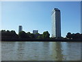
South Bank of The Thames in Rotherhithe, London
As seen from a Thames pleasure boat.
Image: © Christine Matthews
Taken: 28 Apr 2009
0.04 miles
2
The Terrace SE8
Part of the Pepys Estate https://municipaldreams.wordpress.com/2015/08/04/the-pepys-estate-deptford-for-the-peaceful-enjoyment-and-well-being-of-londoners/ a former Royal Navy victualling yard dating back as far as Henry VIII, it was redeveloped in the 1960's for social housing.
Image: © Glyn Baker
Taken: 19 Jul 2017
0.06 miles
3
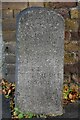
Old Boundary Marker on Grove Street, Deptford
Turnpike Terminus Marker against the brick wall of 1-8 The Colonnade on the east side of the B206 Grove Street, Deptford SE8.
Inscribed
1855
THIS LAND
IS
PART OF THE
BERMONDSEY
ROTHERHITHE
AND
DEPTFORD
TURNPIKE
ROADS
Milestone Society National ID: KE_BSt
Image: © J Dunford
Taken: 8 Nov 2021
0.06 miles
4
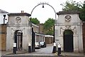
The Colonnade SE8
The entrance to the former Deptford Royal Naval victualling yard. The yard was active from the time of Henry VIII until the 1960's when it was redeveloped for Social Housing by the GLC as the Pepys Estate see https://municipaldreams.wordpress.com/2015/08/04/the-pepys-estate-deptford-for-the-peaceful-enjoyment-and-well-being-of-londoners/ Note the bollards were cast from the same as ships cannon.
Image: © Glyn Baker
Taken: 19 Jul 2017
0.07 miles
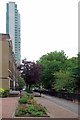
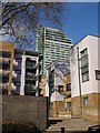
5
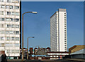
Pepys Estate, Grove Street
The two towers seen from Oxestalls Road. The estate was built by the London County Council in 1963-66.
A third tower was "privatised", as explained here: Image
Image: © Stephen Richards
Taken: 1 Apr 2012
0.07 miles
6
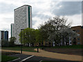
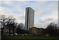
Daubeney Tower, Deptford
This is a view of the tower from a riverside park to the east. It is also seen from different angles in Image and Image
Image: © Stephen Craven
Taken: 2 Apr 2011
0.07 miles
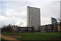
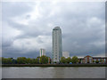
9
Flats and houses in SE8
This development is close to the Thames near Deptford. Above the buildings on Barfleur Lane and Longshore rises what is mapped as Aragon Tower, but see Image
Image: © Derek Harper
Taken: 9 Feb 2011
0.08 miles