IMAGES TAKEN NEAR TO
Penhall Road, LONDON, SE7 8RX
Introduction
This page details the photographs taken nearby to Penhall Road, SE7 8RX by members of the Geograph project.
The Geograph project started in 2005 with the aim of publishing, organising and preserving representative images for every square kilometre of Great Britain, Ireland and the Isle of Man.

There are currently over 7.5m images from over14,400 individuals and you can help contribute to the project by visiting https://www.geograph.org.uk
Image Map
Images are licensed for reuse under creativecommons.org/licenses/by-sa/2.0
Notes
- Clicking on the map will re-center to the selected point.
- The higher the marker number, the further away the image location is from the centre of the postcode.
Image Listing (163 Images Found)
Images are licensed for reuse under creativecommons.org/licenses/by-sa/2.0
Image
Details
Distance
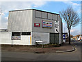
1
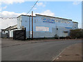
Unit 2, Penhall Road
This building appears to have had so many owners, judging from the palimpsest of signs on the wall, that it's difficult to know who is there now. One former business, now overwritten was stonehill.co.uk - an office supplies company - and there are also old signs for motor repair businesses.
Image: © Stephen Craven
Taken: 17 Feb 2013
0.01 miles
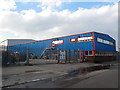
2
Selwood Plant Hire, Penhall Road
One of the newer industrial buildings on Penhall Road Image
Image: © Stephen Craven
Taken: 17 Feb 2013
0.04 miles
3
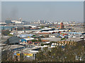
New Charlton Industrial Estate
These are the light industrial units off Westmoor Street and Penhall Road, between the A206 (Woolwich Road) and the River Thames. The view is from the vantage point above Gilbert's Pit Image
Image: © Stephen Craven
Taken: 18 Apr 2010
0.05 miles
4
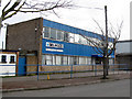
Motor Medics, Penhall Road
One of several motor repair businesses in this area.
Image: © Stephen Craven
Taken: 17 Feb 2013
0.05 miles
5
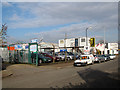
Instalcom, Charlton
The yard of a cable installation contractor, on the Stonelake Industrial Park off Woolwich Road, Charlton.
Image: © Stephen Craven
Taken: 17 Feb 2013
0.05 miles
6
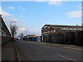
Penhall Road, Charlton
Unlike many of the other roads serving business parks and industrial estates in this area, Penhall Road has a longer history, appearing on old maps.
Image: © Stephen Craven
Taken: 17 Feb 2013
0.06 miles
7
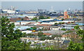
New Charlton & beyond, London
The view from the summit of Cox's Mount, part of Gilbert's Pit in Maryon Park. The summit was home to a Roman hill fort in C1st-C4th, artefacts of which were discovered in 1915. In the 1850s Cox's Mount was also used by ships' captains on the River Thames to assist them in navigating. The former Gilbert's Pit, an area that was worked for fine sand from c.1780s until 1889 is now part of Maryon Park but is separated from it by this ascending spur of land that juts out towards the River Thames. This viewpoint is a fenced-off area of a few square metres only situated at the top of a flight of steps (of earth and railway sleeper construction) located adjacent to the Charlton Lane railway crossing.
Image: © David Hallam-Jones
Taken: 4 May 2014
0.07 miles
8
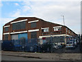
Anonymous factory on Penhall Road
I have not been able to identify the operators of this older building on Penhall Road Image
Image: © Stephen Craven
Taken: 17 Feb 2013
0.07 miles
9
LRR MOT services, Westmoor Street, Charlton
One of several motor repair businesses in this area. This one is on the corner of Penhall road.
Image: © Stephen Craven
Taken: 17 Feb 2013
0.08 miles
10

KBS Builders Merchants, Charlton
One of several builders merchants in and around the Stonelake Industrial Park off Woolwich Road, Charlton.
Image: © Stephen Craven
Taken: 17 Feb 2013
0.09 miles