IMAGES TAKEN NEAR TO
Charlton Park Road, LONDON, SE7 8HX
Introduction
This page details the photographs taken nearby to Charlton Park Road, SE7 8HX by members of the Geograph project.
The Geograph project started in 2005 with the aim of publishing, organising and preserving representative images for every square kilometre of Great Britain, Ireland and the Isle of Man.

There are currently over 7.5m images from over14,400 individuals and you can help contribute to the project by visiting https://www.geograph.org.uk
Image Map
Images are licensed for reuse under creativecommons.org/licenses/by-sa/2.0
Notes
- Clicking on the map will re-center to the selected point.
- The higher the marker number, the further away the image location is from the centre of the postcode.
Image Listing (60 Images Found)
Images are licensed for reuse under creativecommons.org/licenses/by-sa/2.0
Image
Details
Distance
1
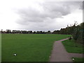
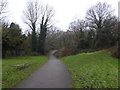
Green Chain Walk in Charlton Park
The long distance path leads from Cemetery Lane through the park towards Charlton Park Road.
Image: © David Anstiss
Taken: 11 Sep 2011
0.03 miles
2
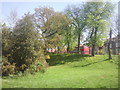
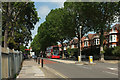
Top end of Maryon Wilson Park
The Green Chain Walk climbs steadily from the Thames through Maryon Park and then Maryon Wilson Park to reach the exit opposite Cemetery Lane. This view looks up the last part of the park to where a bus waits at the stop in Littleheath.
Image: © Marathon
Taken: 7 Apr 2011
0.04 miles
3
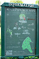
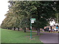
Information board, Maryon Wilson Park
Giving the history of the park, this is to the right of the camera in Image
Image: © Derek Harper
Taken: 26 Jun 2019
0.04 miles
4
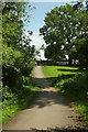
Green Chain Walk, Maryon Wilson Park
A reverse view of Image
Image: © Derek Harper
Taken: 26 Jun 2019
0.05 miles
5
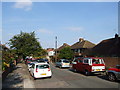
Little Heath
The B210, seen from opposite the junction with Cemetery Lane. Ah, a 53 - I should probably try and catch the next one of those.
Image: © Derek Harper
Taken: 26 Jun 2019
0.06 miles
6
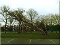
Fallen tree in Charlton Park (2)
There were several severe storms in England around the end of 2013, including one on Monday 23 December, in which this tree had been blown over. The entrance to the car park had been closed for safety.
Image: © Stephen Craven
Taken: 25 Dec 2013
0.06 miles
8
Green Chain Walk in Charlton Park
The long distance path leads from Cemetery Lane, then right towards Charlton Park Road (leading towards the Thames Barrier). The Capital Ring (another long distance path) heads through the park (via the avenue of trees) towards Queen Elizabeth Hospital.
Image: © David Anstiss
Taken: 11 Sep 2011
0.07 miles
9
Maryon Wilson Park in winter
The land now taken up by Maryon Wilson Park was once part of the Hanging Wood which originally stretched from Woolwich Common to Charlton and which provided shelter for the highwaymen of Shooters Hill and Blackheath. Samuel Pepys often told of his dread of Hanging Wood when he was obliged to travel to Woolwich. Although still woodland it is rather more peaceful nowadays. The path followed by the Green Chain Walk and Capital Ring climbs steadily from the Thames through Maryon Park and then Maryon Wilson Park to reach the exit opposite Cemetery Lane. This view looks down the hill from that entrance.
Image: © Marathon
Taken: 31 Jan 2017
0.07 miles
10

The Capital Ring (006)
Here the walk enters Charlton Park from Charlton Park Road.
Image: © Shazz
Taken: 29 Mar 2019
0.08 miles