IMAGES TAKEN NEAR TO
Cleveley Close, LONDON, SE7 8FQ
Introduction
This page details the photographs taken nearby to Cleveley Close, SE7 8FQ by members of the Geograph project.
The Geograph project started in 2005 with the aim of publishing, organising and preserving representative images for every square kilometre of Great Britain, Ireland and the Isle of Man.

There are currently over 7.5m images from over14,400 individuals and you can help contribute to the project by visiting https://www.geograph.org.uk
Image Map
Images are licensed for reuse under creativecommons.org/licenses/by-sa/2.0
Notes
- Clicking on the map will re-center to the selected point.
- The higher the marker number, the further away the image location is from the centre of the postcode.
Image Listing (243 Images Found)
Images are licensed for reuse under creativecommons.org/licenses/by-sa/2.0
Image
Details
Distance
3
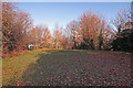
Entrance to Maryon Park
On the corner of Tamar Street, outside the gate, was once a small general store. The four trees have grown somewhat in the last 33 years.
Image: © Dylan Moore
Taken: 29 Nov 2019
0.03 miles
4
Gate to Maryon Park
From Clevely Close, Before re-development in the late 1960s, this was Tamar Street, and in the nineteenth century it was Charlotte Street.
Image: © Dylan Moore
Taken: 29 Nov 2019
0.03 miles
5
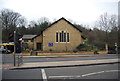
Church of St Catherine Laboure (Roman Catholic)
Image: © N Chadwick
Taken: 17 Feb 2012
0.04 miles
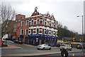
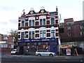
8
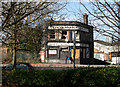
Woolwich : derelict public house
Last photographed by this contributor in 2011 - Image
Image: © Jim Osley
Taken: 24 Feb 2022
0.05 miles
9
Cox's Mount: Maryon Park
The north end of the Mount: at centre view, a path descends to Maryon Road (once called Mount Street).
Image: © Dylan Moore
Taken: 29 Nov 2019
0.06 miles
10
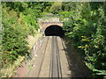
Railway tunnel under Maryon Park
The North Kent Line through Charlton opened in 1849. East of Charlton station and the level crossing at Charlton Lane it passes through two tunnels in quick succession, separated by the Green Chain Path footbridge in Maryon Park. This is the view from the footbridge looking towards Mount Street Tunnel, the second of the tunnels at 121 yards long. The wooded surroundings are also part of Maryon Park.
Image: © Marathon
Taken: 29 Sep 2012
0.06 miles