IMAGES TAKEN NEAR TO
Victoria Way, LONDON, SE7 7TX
Introduction
This page details the photographs taken nearby to Victoria Way, SE7 7TX by members of the Geograph project.
The Geograph project started in 2005 with the aim of publishing, organising and preserving representative images for every square kilometre of Great Britain, Ireland and the Isle of Man.

There are currently over 7.5m images from over14,400 individuals and you can help contribute to the project by visiting https://www.geograph.org.uk
Image Map
Images are licensed for reuse under creativecommons.org/licenses/by-sa/2.0
Notes
- Clicking on the map will re-center to the selected point.
- The higher the marker number, the further away the image location is from the centre of the postcode.
Image Listing (198 Images Found)
Images are licensed for reuse under creativecommons.org/licenses/by-sa/2.0
Image
Details
Distance
1
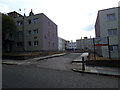
Mascalls Court, Charlton
The entrance from Victoria Way.
Image: © Stephen Craven
Taken: 14 Jul 2013
0.03 miles
2
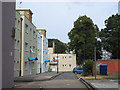
Mascalls Court, Charlton
The entrance from Mascalls Road.
Image: © Stephen Craven
Taken: 14 Jul 2013
0.03 miles
3
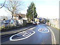
Mascalls Road - new speed markings
One of several suburban streets north of Charlton Road that became a 20mph zone in January 2014. But it is a narrow street with a blind corner a little below this, and traffic would rarely have been exceeding 20mph anyway.
Image: © Stephen Craven
Taken: 19 Jan 2014
0.03 miles
4
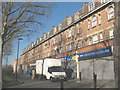
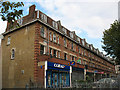
Shops on Charlton Road
The attractive architecture of this parade of shops is spoiled by the necessity of steel security shutters when they are closed (as here, on a Sunday).
Image: © Stephen Craven
Taken: 17 Feb 2008
0.04 miles
5

Shops on Charlton Road (3)
Compare with 1541720 taken 16 months earlier. Even in that short time there have been changes: the opticians (2nd unit from left) has changed its name from Ray Small to Page & Small, and the off-licence (4th from left) has been taken over by the Nisa chain. The buildings were also being renovated at this time.
Image: © Stephen Craven
Taken: 27 Feb 2011
0.05 miles
6
Shops on Charlton Road (2)
See Image for a view from the other end of the parade. The buildings have attractive architectural detail at first and scond floor level that are spoilt by the modern plastic shop signs below.
Image: © Stephen Craven
Taken: 18 Oct 2009
0.05 miles
7
Mascalls Road - new home zone
One of several suburban streets north of Charlton Road that became a 20mph zone in January 2014.
Image: © Stephen Craven
Taken: 19 Jan 2014
0.05 miles
8
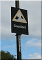
Caution (children playing)
This is a non-standard roadsign. It probably dates from when the nearby Cherry Orchard estate was built (I have yet to find a date for it but probably 1960s). The red of the child and the warning triangle have faded to the point of being almost invisible to passing motorists.
Image: © Stephen Craven
Taken: 18 Oct 2009
0.06 miles
9
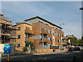
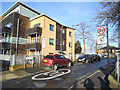
SENSE7 development, Charlton Road
The unusual name of this housing development seems to be a word play on the postcode district (London SE7). It was built in 2007/8.
Image: © Stephen Craven
Taken: 20 Sep 2008
0.06 miles
10

Champion House
The rear of a block of apartments built in 2006/7 as part of the SENSE7 development (mixed private and social housing), with its own car park.
Image: © Stephen Craven
Taken: 9 Jul 2013
0.06 miles