IMAGES TAKEN NEAR TO
Greenwich Shopping Park, Bugsbys Way, LONDON, SE7 7SR
Introduction
This page details the photographs taken nearby to Greenwich Shopping Park, Bugsbys Way, SE7 7SR by members of the Geograph project.
The Geograph project started in 2005 with the aim of publishing, organising and preserving representative images for every square kilometre of Great Britain, Ireland and the Isle of Man.

There are currently over 7.5m images from over14,400 individuals and you can help contribute to the project by visiting https://www.geograph.org.uk
Image Map
Images are licensed for reuse under creativecommons.org/licenses/by-sa/2.0
Notes
- Clicking on the map will re-center to the selected point.
- The higher the marker number, the further away the image location is from the centre of the postcode.
Image Listing (87 Images Found)
Images are licensed for reuse under creativecommons.org/licenses/by-sa/2.0
Image
Details
Distance
1
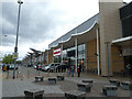
Matalan, Peninsular Park, Charlton
This row of shops has been here for at least 15 years, with just the Starbucks to the right added more recently Image
Image: © Stephen Craven
Taken: 28 Apr 2019
0.04 miles
3
Former Maritime Industrial Estate, Charlton
This is a photo taken through a gap in a developer's hoarding. The 2009 planning application on a nearby lamp-post identified the former use of the site as "Maritime Industrial Estate, Horizon Way" though that street name does not appears on local street maps. The application was for a mixed-use development of housing, retail and trade units. The 2009/10 recession appeared to have prevented development from starting.
See Image for after completion of demolition in 2013.
Image: © Stephen Craven
Taken: 18 Apr 2010
0.06 miles
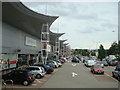
4
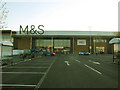
Marks and Spencer, Charlton: front view
The new large M&S store was billed as being on Woolwich Road, although the main entrance actually turns out to be from Bugsbys Way to the north. There is however pedestrian access from the bus stops on Woolwich Road.
Image: © Stephen Craven
Taken: 30 Jun 2015
0.07 miles
5
Starbucks, Woolwich Road
Since my last photograph of what was then a vacant site in 2013 Image this Starbucks, together with its outdoor seating area, have been added to the end of the existing Matalan store. The barista reckoned they had been open for five years (i.e. since 2014) which makes sense.
Image: © Stephen Craven
Taken: 28 Apr 2019
0.07 miles
6
Maritime Industrial estate: demolition complete
Since my previous photo of this site three years earlier Image demolition had been completed, and planning permission granted in December 2012 for a large retail development (principally Sainsbury and Marks & Spencer).
Image: © Stephen Craven
Taken: 17 Feb 2013
0.08 miles
7

Sainsbury's, Charlton Riverside: ATMs and trolley park
This new store opened on 24 June 2015, replacing the one on the peninsula about 800m away Image
Image: © Stephen Craven
Taken: 30 Jun 2015
0.08 miles
8
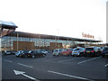
Sainsbury's, Charlton Riverside: front view
The new large Sainsbury's store opened on 24 June 2015, replacing the one on the peninsula about 800m away Image It was billed as being on Woolwich Road, although the main entrance actually turns out to be from Bugsbys Way to the north.
Image: © Stephen Craven
Taken: 30 Jun 2015
0.08 miles
9
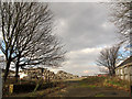
London and Kent Electrical, Woolwich Road
Most of the older houses on the north side of this stretch of Woolwich Road had already been demolished by the end of 2012. The few that remained probably survived (though boarded up) because of this shop on the west end. But sooner or later they will go to make way for construction of the new shopping centre.
Image: © Stephen Craven
Taken: 17 Feb 2013
0.08 miles
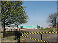
10
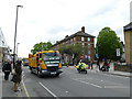
Marathon clearup (1)
After nearly all the runners had gone through, the cleanup beings. The white-lining team were using high pressure jets to remove temporary road markings.
Image: © Stephen Craven
Taken: 28 Apr 2019
0.09 miles