IMAGES TAKEN NEAR TO
Priolo Road, LONDON, SE7 7PX
Introduction
This page details the photographs taken nearby to Priolo Road, SE7 7PX by members of the Geograph project.
The Geograph project started in 2005 with the aim of publishing, organising and preserving representative images for every square kilometre of Great Britain, Ireland and the Isle of Man.

There are currently over 7.5m images from over14,400 individuals and you can help contribute to the project by visiting https://www.geograph.org.uk
Image Map
Images are licensed for reuse under creativecommons.org/licenses/by-sa/2.0
Notes
- Clicking on the map will re-center to the selected point.
- The higher the marker number, the further away the image location is from the centre of the postcode.
Image Listing (121 Images Found)
Images are licensed for reuse under creativecommons.org/licenses/by-sa/2.0
Image
Details
Distance
1
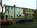
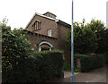
Renovated houses on Wellington Gardens
This pair of houses was behind hoardings for most of 2013 as they were renovated prior to re-sale or letting.
Image: © Stephen Craven
Taken: 25 Dec 2013
0.04 miles
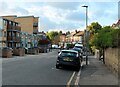
2
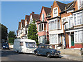
Towing power
The Morris Minor is not usually regarded as the best choice for pulling a caravan but it looked as if someone was going to give it a go. The location is Wellington Gardens, Charlton.
Image: © Stephen Craven
Taken: 26 Jul 2014
0.04 miles
4
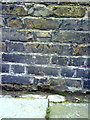
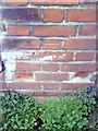
Benchmark on the wall of Wellington Gardens
Ordnance Survey cut mark benchmark described on the Bench Mark Database at http://www.bench-marks.org.uk/bm36084
Image: © Roger Templeman
Taken: 20 Nov 2010
0.07 miles
6
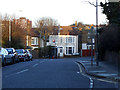
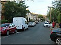
Victoria Way, adverse gradient
Victoria way generally rises north to south, gaining 40m of height in just over 1km. But here it turns eastward and drops 5 metres.
Image: © Stephen Craven
Taken: 16 Feb 2014
0.08 miles
7
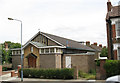
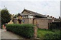
St Richard's church and hall, Charlton
A church hall belonging to St Luke's parish, with a 30-seater chapel beneath the east end used for occasional services. Designed by Ralph Covell and built in 1958.
Image: © Stephen Craven
Taken: 16 Jul 2007
0.08 miles
10
Benchmark on #29 Nadine Street
Ordnance Survey cut mark benchmark described on the Bench Mark Database at http://www.bench-marks.org.uk/bm36085
Image: © Roger Templeman
Taken: 20 Nov 2010
0.11 miles