IMAGES TAKEN NEAR TO
Swallowfield Road, LONDON, SE7 7NR
Introduction
This page details the photographs taken nearby to Swallowfield Road, SE7 7NR by members of the Geograph project.
The Geograph project started in 2005 with the aim of publishing, organising and preserving representative images for every square kilometre of Great Britain, Ireland and the Isle of Man.

There are currently over 7.5m images from over14,400 individuals and you can help contribute to the project by visiting https://www.geograph.org.uk
Image Map
Images are licensed for reuse under creativecommons.org/licenses/by-sa/2.0
Notes
- Clicking on the map will re-center to the selected point.
- The higher the marker number, the further away the image location is from the centre of the postcode.
Image Listing (130 Images Found)
Images are licensed for reuse under creativecommons.org/licenses/by-sa/2.0
Image
Details
Distance
1
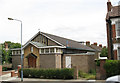
St Richard's church and hall, Charlton
A church hall belonging to St Luke's parish, with a 30-seater chapel beneath the east end used for occasional services. Designed by Ralph Covell and built in 1958.
Image: © Stephen Craven
Taken: 16 Jul 2007
0.01 miles
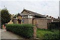
4
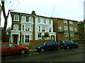
Swallowfield Road
Typical of the suburban streets in the area.
Image: © Stephen Craven
Taken: 16 Jul 2007
0.05 miles
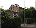
5

Path to Victoria Way
This footpath leads from the junction of Inverine Road and Delafield Road (foreground) to Victoria Way.
Image: © Stephen Craven
Taken: 16 Feb 2014
0.09 miles
6

Frank Burton Close
A small close of houses off Victoria Way, named after a man who played for nearby Charlton Athletic from 1921-1924.
Image: © Stephen Craven
Taken: 16 Feb 2014
0.09 miles
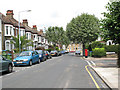
7
Renovated houses on Wellington Gardens
This pair of houses was behind hoardings for most of 2013 as they were renovated prior to re-sale or letting.
Image: © Stephen Craven
Taken: 25 Dec 2013
0.09 miles
8
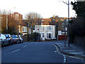
Victoria Way, adverse gradient
Victoria way generally rises north to south, gaining 40m of height in just over 1km. But here it turns eastward and drops 5 metres.
Image: © Stephen Craven
Taken: 16 Feb 2014
0.10 miles
9
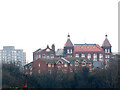
Fossdene School, Charlton
The tall, brick primary school building is typical of several in the area. The topography of the area means that this view from 800m to the west is probably the clearest view of the building's twin towers.
In 2006 the Government planned to rebuild every primary school in the UK by 2020, but that plan has since been severely cut back. These solidly built Victorian schools well may outlast many a late 20th century one.
Image: © Stephen Craven
Taken: 14 Feb 2009
0.10 miles
10
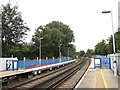
Extending the platforms at Charlton Station
Along with most stations on the North Kent suburban lines, the platforms at Charlton were being extended to take 12-car trains. This end of the platforms is across a grid line from the rest of the station in TQ4178. Beyond the platforms can be seen the junction where direct trains to London take the right-hand pair of tracks, and those on the older route via Blackheath keep left.
Image: © Stephen Craven
Taken: 10 Aug 2013
0.10 miles