IMAGES TAKEN NEAR TO
Bowen Drive, LONDON, SE7 7FZ
Introduction
This page details the photographs taken nearby to Bowen Drive, SE7 7FZ by members of the Geograph project.
The Geograph project started in 2005 with the aim of publishing, organising and preserving representative images for every square kilometre of Great Britain, Ireland and the Isle of Man.

There are currently over 7.5m images from over14,400 individuals and you can help contribute to the project by visiting https://www.geograph.org.uk
Image Map (Loading...)


Getting Data...Please wait
Leaflet Map data © OpenStreetMap
Images are licensed for reuse under creativecommons.org/licenses/by-sa/2.0
Notes
- Clicking on the map will re-center to the selected point.
- The higher the marker number, the further away the image location is from the centre of the postcode.
Image Listing (109 Images Found)
Images are licensed for reuse under creativecommons.org/licenses/by-sa/2.0
Image
Details
Distance
1
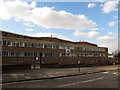
CINTAS warehouse, Charlton: east side
This is a huge warehouse, about 70m long on the street frontage, part of which is shown here, and 150m deep. CINTAS is a multinational business services company, and document storage is one of their key services.
Image: © Stephen Craven
Taken: 17 Feb 2013
0.01 miles
2
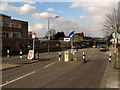
Seven feet width
A deliberate narrowing of the road (Victoria Way) to prevent rat-running by large vehicles.
Image: © Stephen Craven
Taken: 17 Feb 2013
0.02 miles
3
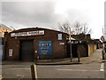
Riverside Garage, Rathmore Road
A small independent motor repair business. I used to take my car here for MOTs.
Image: © Stephen Craven
Taken: 17 Feb 2013
0.02 miles
5
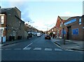
The Gateway, Rathmore Road
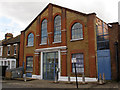
This is a small business centre. In fact, a Google search reveals far more businesses registered here than you would think could be accommodated in a building this size.
Image: © Stephen Craven
Taken: 17 Feb 2013
0.03 miles
6
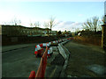
Victoria Way bridge narrowing
Council workmen were in the process of narrowing the railway bridge on Victoria Way to a single traffic lane, with safety kerbs to protect the bridge parapets.
Image: © Stephen Craven
Taken: 16 Feb 2014
0.04 miles
7
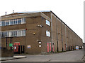
CINTAS warehouse, Charlton: north side
This is a huge warehouse, about 70m long on the street frontage, and 150m deep as seen here. CINTAS is a multinational business services company, and document storage is one of their key services.
Image: © Stephen Craven
Taken: 17 Feb 2013
0.05 miles
8
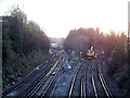
Track maintenance at Charlton Junction
For another view, and history, see Image
Image: © Stephen Craven
Taken: 16 Feb 2014
0.05 miles
9
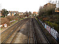
Charlton Junction
A view eastwards from Victoria Way bridge, to where the two lines join just west of Charlton station. The tracks on the right are on the original route from London via Blackheath in 1849; the gap from Greenwich to here (the tracks on the left) was filled in 1873. There is a 40mph speed restriction sign to the left.
See Image for the view in the other direction from the same bridge.
Image: © Stephen Craven
Taken: 17 Feb 2013
0.06 miles
10
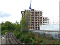
New apartments being built by the railway in Charlton
One of several blocks now going up on the site of the former CINTAS warehouse Image adjacent to Angerstein's Junction.
Image: © Stephen Craven
Taken: 28 Apr 2019
0.06 miles