IMAGES TAKEN NEAR TO
Fairthorn Road, LONDON, SE7 7FW
Introduction
This page details the photographs taken nearby to Fairthorn Road, SE7 7FW by members of the Geograph project.
The Geograph project started in 2005 with the aim of publishing, organising and preserving representative images for every square kilometre of Great Britain, Ireland and the Isle of Man.

There are currently over 7.5m images from over14,400 individuals and you can help contribute to the project by visiting https://www.geograph.org.uk
Image Map (Loading...)


Getting Data...Please wait
Leaflet Map data © OpenStreetMap
Images are licensed for reuse under creativecommons.org/licenses/by-sa/2.0
Notes
- Clicking on the map will re-center to the selected point.
- The higher the marker number, the further away the image location is from the centre of the postcode.
Image Listing (155 Images Found)
Images are licensed for reuse under creativecommons.org/licenses/by-sa/2.0
Image
Details
Distance
1
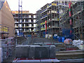
New development off Fairthorn Road
Looking through the gate of a construction site at the southern end of Fairthorn Road, towards apartment blocks and town houses under construction.
Sadly there appears to be no Geograph photo of the warehouses formerly on the site.
Image: © Stephen Craven
Taken: 10 Nov 2013
0.06 miles
2
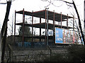
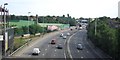
Development halted
This steel-framed structure to the east of the A102 was erected a few years before the photo was taken but has not yet been completed.
Image: © Stephen Craven
Taken: 16 Jan 2011
0.08 miles
3
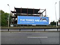
The Tories are Lying
Brexit related political sign along the A102.
Image: © Oast House Archive
Taken: 17 Oct 2019
0.08 miles
7
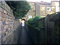
Snicket off Fairthorn Road
This urban footpath links the residential streets east of the A102 with Westcombe Park station via a railway level crossing and footbridge. See Image for a reverse view by another contributor.
Image: © Stephen Craven
Taken: 10 Nov 2013
0.10 miles
8

Entrance to footpath leading across Angerstein Wharf branch line
This passage way from Fairthorn Road leads across the branch railway line to Angerstein Wharf before crossing the Blackwall Tunnel Approach.
For more information, an update and photographs see https://www.ianvisits.co.uk/blog/2021/05/31/londons-alleys-fairthorne-road-se7/?utm_source=newsletter&utm_medium=email&utm_campaign=weeklyemailblog
Image: © Marathon
Taken: 7 Apr 2011
0.10 miles
9
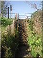
Steps up to Angerstein Wharf branch line
After passing under a house in Fairthorn Road and between back gardens, these steps take you up to cross over the Angerstein Wharf branch railway line.
For more information, an update and photographs see https://www.ianvisits.co.uk/blog/2021/05/31/londons-alleys-fairthorne-road-se7/?utm_source=newsletter&utm_medium=email&utm_campaign=weeklyemailblog
Image: © Marathon
Taken: 7 Apr 2011
0.10 miles
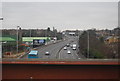
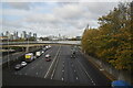
10
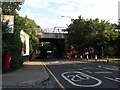
Railway bridge over Westcombe Hill
The tail end of an eastbound Thameslink train crosses the bridge as a bus passes beneath.
Image: © Stephen Craven
Taken: 16 Sep 2021
0.10 miles