IMAGES TAKEN NEAR TO
Bournville Road, LONDON, SE6 4RN
Introduction
This page details the photographs taken nearby to Bournville Road, SE6 4RN by members of the Geograph project.
The Geograph project started in 2005 with the aim of publishing, organising and preserving representative images for every square kilometre of Great Britain, Ireland and the Isle of Man.

There are currently over 7.5m images from over14,400 individuals and you can help contribute to the project by visiting https://www.geograph.org.uk
Image Map
Images are licensed for reuse under creativecommons.org/licenses/by-sa/2.0
Notes
- Clicking on the map will re-center to the selected point.
- The higher the marker number, the further away the image location is from the centre of the postcode.
Image Listing (194 Images Found)
Images are licensed for reuse under creativecommons.org/licenses/by-sa/2.0
Image
Details
Distance
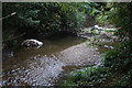
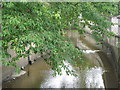
2
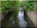
Ravensbourne River, Catford
The Ravensbourne flows to Lewisham where it meets the Quaggy River.
Image: © Danny P Robinson
Taken: 12 May 2007
0.04 miles
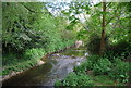
5
View of the Ravensbourne flowing through Ladywell Fields
Looking south-southeast.
Image: © Robert Lamb
Taken: 19 Aug 2018
0.05 miles
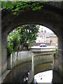
6
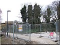
Work at Ladywell Fields
Considerable public works, costing almost £2m, are in progress on Ladywell Fields. Here at the southern end, the entrance from Burnville Road has been closed off by fencing. On the left can be seen Image
Image: © Derek Harper
Taken: 11 Mar 2011
0.05 miles
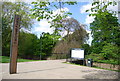
9
The River Ravensbourne at the southern end of Ladywell Fields (5)
The River Ravensbourne formerly ran along the eastern edge of the park, hidden behind railings and dense vegetation. The concrete channel is still there in places, but new meanders have been created, running some of the water through the middle of the park - see http://www.therrc.co.uk/case_studies/ladywell_fields.pdf.
Image: © Mike Quinn
Taken: 5 Aug 2009
0.05 miles
10
The River Ravensbourne north of Catford station
See also Image
Image: © Mike Quinn
Taken: 5 Aug 2009
0.06 miles