IMAGES TAKEN NEAR TO
Adenmore Road, LONDON, SE6 4DZ
Introduction
This page details the photographs taken nearby to Adenmore Road, SE6 4DZ by members of the Geograph project.
The Geograph project started in 2005 with the aim of publishing, organising and preserving representative images for every square kilometre of Great Britain, Ireland and the Isle of Man.

There are currently over 7.5m images from over14,400 individuals and you can help contribute to the project by visiting https://www.geograph.org.uk
Image Map
Images are licensed for reuse under creativecommons.org/licenses/by-sa/2.0
Notes
- Clicking on the map will re-center to the selected point.
- The higher the marker number, the further away the image location is from the centre of the postcode.
Image Listing (157 Images Found)
Images are licensed for reuse under creativecommons.org/licenses/by-sa/2.0
Image
Details
Distance
1
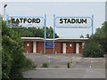
The entrance to (the former) Catford Stadium
Image: © Mike Quinn
Taken: 5 Aug 2009
0.00 miles
2
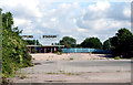
Catford: The entrance to the derelict dog track
Catford Stadium closed years ago but nothing has been done to re-use the site, which I believe belongs to Lewisham Council. I had to take this shot with a very long lens poked through a security fence, as the 'jobsworth' on duty refused to unlock the barrier to enable me to get closer.
Image: © Dr Neil Clifton
Taken: 23 Aug 2012
0.03 miles
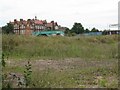
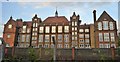
4
The remains of Catford Stadium
The Image (photographed by Sue Hayton) was open from 1932 to 2003. A planning application for a major redevelopment including 575 houses and flats, shops and a community centre was submitted in August 2007 - see http://www.hsiltd.co.uk/projects/buildings__infrastructure/mixed_use_developments/catford_stadium_redevelopment.aspx. But in March 2010 the plans fell through - see http://www.catfordcentral.com/plans-fall-through-for-catford-stadium. As the Deputy Mayor of Lewisham said at that time “... the overgrown site is an eyesore.”.
Image: © Mike Quinn
Taken: 5 Aug 2009
0.04 miles
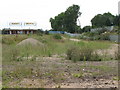
5
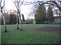
Open space with shelter, Ladywell Fields
The space is adjacent to the bowling club Image and tennis courts. It may also have been a dedicated sports facility at one time but is now just an open space with self-seeded birch trees and a simple shelter.
Image: © Stephen Craven
Taken: 26 Dec 2009
0.05 miles
6
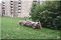
View of a log in front of flats in the Catford Green development from Ladywell Fields
Looking north-northeast.
Image: © Robert Lamb
Taken: 19 Aug 2018
0.05 miles

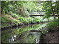
9
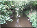
The River Ravensbourne at the southern end of Ladywell Fields
The River Ravensbourne formerly ran along the eastern edge of the park, hidden behind railings and dense vegetation. The concrete channel is still there in places, but new meanders have been created, running some of the water through the middle of the park - see http://www.therrc.co.uk/case_studies/ladywell_fields.pdf.
Image: © Mike Quinn
Taken: 5 Aug 2009
0.07 miles
10
The River Ravensbourne in Ladywell Fields (19)
The River Ravensbourne formerly ran along the eastern edge of the park, hidden behind railings and dense vegetation. The concrete channel is still there in places, but new meanders have been created, running some of the water through the middle of the park - see http://www.therrc.co.uk/case_studies/ladywell_fields.pdf.
Image: © Mike Quinn
Taken: 5 Aug 2009
0.07 miles