IMAGES TAKEN NEAR TO
Firhill Road, LONDON, SE6 3SH
Introduction
This page details the photographs taken nearby to Firhill Road, SE6 3SH by members of the Geograph project.
The Geograph project started in 2005 with the aim of publishing, organising and preserving representative images for every square kilometre of Great Britain, Ireland and the Isle of Man.

There are currently over 7.5m images from over14,400 individuals and you can help contribute to the project by visiting https://www.geograph.org.uk
Image Map
Images are licensed for reuse under creativecommons.org/licenses/by-sa/2.0
Notes
- Clicking on the map will re-center to the selected point.
- The higher the marker number, the further away the image location is from the centre of the postcode.
Image Listing (122 Images Found)
Images are licensed for reuse under creativecommons.org/licenses/by-sa/2.0
Image
Details
Distance
1
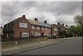
Houses on Moremead Road, SE6
A lovely, if chilly, spring day, has temporarily turned very miserable. This is one of many terraces of four on this estate at Bellingham.
Image: © Derek Harper
Taken: 9 May 2013
0.09 miles
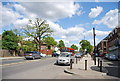
2
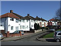
Moremead Road, Bellingham
Houses on Moremead Road, Bellingham. Bellingham Estate is a large estate of council housing, built by the London County Council in the 1920s.
Image: © Malc McDonald
Taken: 19 Mar 2011
0.12 miles
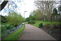
3
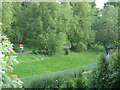
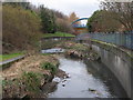
Waterlink Way at Bell Green
As part of the development of the Bell Green gas works site, the section of the river that ran in a culvert under the gas works has been diverted, opened up, landscaped and now forms part of the Waterlink Way.
Image: © Stephen Craven
Taken: 8 Jun 2008
0.13 miles
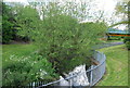
4
River Pool facing S
This picture was taken from the bridge over the River Pool behind the Sainsbury's Sava Centre at lower Sydenham/Bell Green.
Image: © Vince Gaines
Taken: 17 Dec 2010
0.13 miles
6
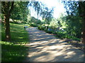
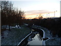
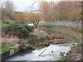
Riverview Walk
The River Pool was opened up and landscaped in 1995-6 to create Riverview Walk, as part of the SaveCentre development on the nearby Bell Green Gas Works site. The River Pool prior to that had run beneath the gas works in a culvert. Unfortunately the landscaping in Riverview Walk, with the hard concrete edges to the river, was not as attractive as in the River Pool Linear Park to the north. This view is looking upriver - the concrete edge of the river can just be seen to the right.
Image: © Marathon
Taken: 22 Jul 2011
0.14 miles
9
The Pool River south of Winsford Road, SE6
Image: © Mike Quinn
Taken: 12 Mar 2010
0.14 miles
10
The Pool River north of Southend Lane (3)
Image: © Mike Quinn
Taken: 12 Mar 2010
0.14 miles