IMAGES TAKEN NEAR TO
Broadmead, LONDON, SE6 3SD
Introduction
This page details the photographs taken nearby to Broadmead, SE6 3SD by members of the Geograph project.
The Geograph project started in 2005 with the aim of publishing, organising and preserving representative images for every square kilometre of Great Britain, Ireland and the Isle of Man.

There are currently over 7.5m images from over14,400 individuals and you can help contribute to the project by visiting https://www.geograph.org.uk
Image Map
Images are licensed for reuse under creativecommons.org/licenses/by-sa/2.0
Notes
- Clicking on the map will re-center to the selected point.
- The higher the marker number, the further away the image location is from the centre of the postcode.
Image Listing (122 Images Found)
Images are licensed for reuse under creativecommons.org/licenses/by-sa/2.0
Image
Details
Distance
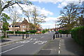
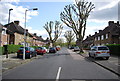
3
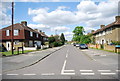
King Alfred Avenue, Bellingham
The naming of this road after an Anglo-Saxon monarch ties in well with the name of the church on the estate (St Dunstan's). The housing dates from the 1920s.
Image: © Stephen Craven
Taken: 29 Jun 2010
0.07 miles
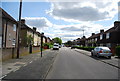
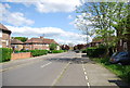
6
Athelney Primary School, Bellingham
On Athelney Street.
Image: © David Anstiss
Taken: 18 Sep 2011
0.08 miles
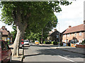
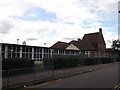
9
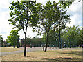
Football pitch at Bellingham Green
An all-weather pitch on the green: see Image
Image: © Stephen Craven
Taken: 29 Jun 2010
0.12 miles