IMAGES TAKEN NEAR TO
Evans Road, LONDON, SE6 1QG
Introduction
This page details the photographs taken nearby to Evans Road, SE6 1QG by members of the Geograph project.
The Geograph project started in 2005 with the aim of publishing, organising and preserving representative images for every square kilometre of Great Britain, Ireland and the Isle of Man.

There are currently over 7.5m images from over14,400 individuals and you can help contribute to the project by visiting https://www.geograph.org.uk
Image Map
Images are licensed for reuse under creativecommons.org/licenses/by-sa/2.0
Notes
- Clicking on the map will re-center to the selected point.
- The higher the marker number, the further away the image location is from the centre of the postcode.
Image Listing (46 Images Found)
Images are licensed for reuse under creativecommons.org/licenses/by-sa/2.0
Image
Details
Distance
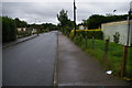
1
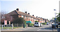
Castillon Road, Catford
Typical housing on the Downham Estate between Catford and Bromley, which when the London County Council built it in the 1920's was said to be one of the largest housing estates in Europe.
Image: © Stephen Craven
Taken: 19 Apr 2007
0.10 miles
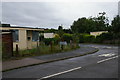
2
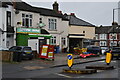
Off licence and convenience store on Verdant Lane
Image: © David Martin
Taken: 15 Feb 2022
0.13 miles
4
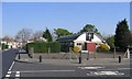
St Mark's Church, North Downham
St Mark's on the corner of Castillon Road and Baudwin Road was originally a prefabricated building erected at the same time as Image The present building dates from around 1960. The cycle markings on the road indicate that the London Cycle Network is routed through the quiet roads of this estate.
Image: © Stephen Craven
Taken: 19 Apr 2007
0.14 miles
5
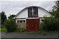
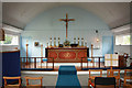
St Mark's church, Downham
Seen from the south (liturgical west).
St Mark's church is the only amenity on the Excalibur Estate of post-war prefabs, and its Nissen-hut style roof is in keeping with the mood of quick post-war reconstruction.
Image: © Christopher Hilton
Taken: 15 Sep 2013
0.14 miles
6
St Mark, Castillon Road, North Downham - East end
Image: © John Salmon
Taken: 1 Feb 2011
0.14 miles
7
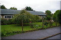
St Mark's church, Downham, and post-war prefabs scheduled for demolition
Church seen from the south (liturgical west).
St Mark's church is the only amenity on the Excalibur Estate of post-war prefabs, and its Nissen-hut style roof is in keeping with the mood of quick post-war reconstruction.
See Image for an image of this area of the estate before the houses were boarded up.
Image: © Christopher Hilton
Taken: 15 Sep 2013
0.14 miles
8
St Mark's church, Downham
Seen from the west (liturgical north).
St Mark's church is the only amenity on the Excalibur Estate of post-war prefabs, and its Nissen-hut style roof is in keeping with the mood of quick post-war reconstruction.
Image: © Christopher Hilton
Taken: 15 Sep 2013
0.14 miles
9
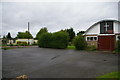
Post-war prefabs scheduled for demolition, Excalibur Estate, Catford
See Image for an image of this area of the estate before the houses were boarded up.
Image: © Christopher Hilton
Taken: 15 Sep 2013
0.14 miles
10
Post-war prefabs scheduled for demolition, Excalibur Estate, Catford
See Image for an image of this area of the estate before the houses were boarded up.
Image: © Christopher Hilton
Taken: 15 Sep 2013
0.14 miles