IMAGES TAKEN NEAR TO
Knatchbull Road, LONDON, SE5 9QY
Introduction
This page details the photographs taken nearby to Knatchbull Road, SE5 9QY by members of the Geograph project.
The Geograph project started in 2005 with the aim of publishing, organising and preserving representative images for every square kilometre of Great Britain, Ireland and the Isle of Man.

There are currently over 7.5m images from over14,400 individuals and you can help contribute to the project by visiting https://www.geograph.org.uk
Image Map
Images are licensed for reuse under creativecommons.org/licenses/by-sa/2.0
Notes
- Clicking on the map will re-center to the selected point.
- The higher the marker number, the further away the image location is from the centre of the postcode.
Image Listing (91 Images Found)
Images are licensed for reuse under creativecommons.org/licenses/by-sa/2.0
Image
Details
Distance
1
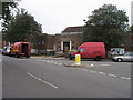
Minet library
Minet library on corner of Burton road and Knatchbull road
Image: © Shaun Ferguson
Taken: 18 Sep 2008
0.01 miles
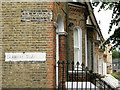
2
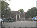
The Minet Library, Knatchbull Road
Home to the Lambeth Archives, the Minet Library replaced the original 1890 building given by William Minet which was bombed in the second world war.
Minet also donated his personal collection of Surrey archives which now forms the core of the Lambeth Archives housed inside.
source: http://www.urban75.org/brixton/features/myatts-fields.html
Image: © Stephen Craven
Taken: 22 Sep 2009
0.03 miles
3
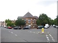
Camberwell, Longfield Hall
Former church hall on Knatchbull Road, used by community groups including dance studio and pre-school: http://www.longfieldhall.org.uk/ The building is dated 1889.
Image: © Mike Faherty
Taken: 24 Jun 2014
0.04 miles
4
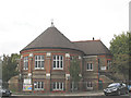
The Longfield Hall, Knatchbull Road
The architecture of the Longfield Hall apparently matched that of the original Minet Library whose replacement stands across the road Image
Image: © Stephen Craven
Taken: 22 Sep 2009
0.05 miles
5
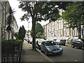
South on Claribel Road
A neat street of brick-built three-storey terrace houses with semi-basements.
Image: © Robin Stott
Taken: 23 Jun 2013
0.07 miles
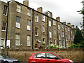
6
North on Paulet Road
The west side of Paulet Road is almost entirely developed with three blocks of 20th-century post-war brick-built monopitch-roofed terraced houses with small gardens at the back. Pleasant places to live, I've no doubt, but visually they brutally confront an older mix of terraced housing across the road. I'm sure it looks better, and would certainly photograph better in sunshine.
Image: © Robin Stott
Taken: 23 Jun 2013
0.07 miles
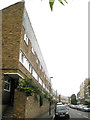
7
Backs of houses, Lilford Road, from Claribel Road
The internal layout of houses is expressed in the positions of the windows.
Image: © Robin Stott
Taken: 23 Jun 2013
0.08 miles
8
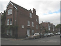
Cormont Road (1893)
The date as well as the road name is on a stone built into the house on the corner.
Image: © Stephen Craven
Taken: 22 Sep 2009
0.09 miles
9
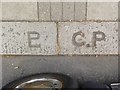
Old Boundary Marker by Burton Road, Camberwell parish
Parish Boundary Marker by the UC road, in parish of Camberwell and Dulwich (Southwark District), Burton Road SW9, in front of No 111 near junction with Brief Street on kerb.
Inscription on left reads:-
LP (combined)
(Lambeth Parish)
Inscription on right reads:-
C.P
(Camberwell Parish)
Surveyed
Milestone Society National ID: SY_LAMB08pb
Milestone Society National ID: SY_SGC19pb
Image: © Milestone Society
Taken: Unknown
0.09 miles
10
Northwest corner of Claribel Road
At its junction with Burton Road. Note the pleasing brick detailing.
Image: © Robin Stott
Taken: 23 Jun 2013
0.10 miles