IMAGES TAKEN NEAR TO
Luxor Street, LONDON, SE5 9QN
Introduction
This page details the photographs taken nearby to Luxor Street, SE5 9QN by members of the Geograph project.
The Geograph project started in 2005 with the aim of publishing, organising and preserving representative images for every square kilometre of Great Britain, Ireland and the Isle of Man.

There are currently over 7.5m images from over14,400 individuals and you can help contribute to the project by visiting https://www.geograph.org.uk
Image Map (Loading...)


Getting Data...Please wait
Leaflet Map data © OpenStreetMap
Images are licensed for reuse under creativecommons.org/licenses/by-sa/2.0
Notes
- Clicking on the map will re-center to the selected point.
- The higher the marker number, the further away the image location is from the centre of the postcode.
Image Listing (60 Images Found)
Images are licensed for reuse under creativecommons.org/licenses/by-sa/2.0
Image
Details
Distance
2
From Loughborough Junction Station
Image: © Andrew Ingamells
Taken: 15 Jan 2013
0.06 miles
4
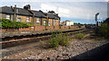
Old Platform at Loughborough Junction
At Loughborough Junction the line divides three ways, going east, south and west.
The station is now only on the south track but this picture is of the eastern track showing an old disused platform.
Taken through the train window. Sorry about the reflections off the glass.
Image: © Des Blenkinsopp
Taken: 25 May 2011
0.07 miles
5
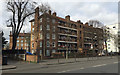
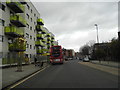
Lilford House flats seen across Coldharbour Lane, Camberwell, south London
Here we are in the London Borough of Lambeth. We see two wings of Lilford House. The central third side faces Lilford Road, the turning before the white block. Lilford House and its neighbour Brigstock House are shown in outline on an OS map of 1938; built on a map of 1949-54.
Image: © Robin Stott
Taken: 20 Feb 2017
0.08 miles
6
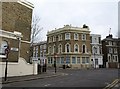
Former Wickwood Tavern, Brixton
As http://www.urban75.org/brixton/bars/wickwood-tavern.html reports, the pub, which was built in 1868 (the date appears in the plaque on top of the angle), closed in 2000. This is the crossroads of Flaxman Road (left) with Eastlake Road (right) / Gordon Grove (foreground).
Image: © Derek Harper
Taken: 11 Mar 2011
0.08 miles
7
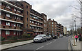
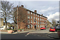
Flats on Lilford Road, Camberwell, south London
Lilford House, nearest, and its neighbour Brigstock House are shown in outline on an OS map of 1938; built on a map of 1949-54. The pale brick block is Winterslow House. The estate is in the London Borough of Lambeth.
Image: © Robin Stott
Taken: 20 Feb 2017
0.09 miles
8
Railway bridge over Coldharbour Lane, London
Image: © JThomas
Taken: 25 Jul 2022
0.10 miles
9
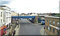
Coldharbour Lane, Camberwell
The flats on the left haven't quite been finished, the other photo shows them just being finished off here http://www.geograph.org.uk/photo/3276141
Image: © David Howard
Taken: 30 Dec 2012
0.11 miles
10
Block of 16 flats, Southwell Road, Camberwell, south London
A post-war contribution to an area of mixed uses including housing of various periods from the 19th century onwards.
Image: © Robin Stott
Taken: 20 Feb 2017
0.11 miles