IMAGES TAKEN NEAR TO
Templar Street, LONDON, SE5 9JB
Introduction
This page details the photographs taken nearby to Templar Street, SE5 9JB by members of the Geograph project.
The Geograph project started in 2005 with the aim of publishing, organising and preserving representative images for every square kilometre of Great Britain, Ireland and the Isle of Man.

There are currently over 7.5m images from over14,400 individuals and you can help contribute to the project by visiting https://www.geograph.org.uk
Image Map
Images are licensed for reuse under creativecommons.org/licenses/by-sa/2.0
Notes
- Clicking on the map will re-center to the selected point.
- The higher the marker number, the further away the image location is from the centre of the postcode.
Image Listing (96 Images Found)
Images are licensed for reuse under creativecommons.org/licenses/by-sa/2.0
Image
Details
Distance
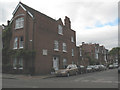
1
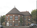
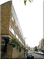
The Longfield Hall, Knatchbull Road
The architecture of the Longfield Hall apparently matched that of the original Minet Library whose replacement stands across the road Image
Image: © Stephen Craven
Taken: 22 Sep 2009
0.06 miles
2
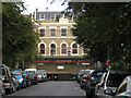
The Paulet Arms (closed)
This pub on Paulet Road, seen from along Templar Street, was closed and "to let" in 2009. It was, according to the legend on the front, established in 1787.
Image: © Stephen Craven
Taken: 22 Sep 2009
0.06 miles
3
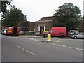
Minet library
Minet library on corner of Burton road and Knatchbull road
Image: © Shaun Ferguson
Taken: 18 Sep 2008
0.06 miles
4
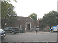
The Minet Library, Knatchbull Road
Home to the Lambeth Archives, the Minet Library replaced the original 1890 building given by William Minet which was bombed in the second world war.
Minet also donated his personal collection of Surrey archives which now forms the core of the Lambeth Archives housed inside.
source: http://www.urban75.org/brixton/features/myatts-fields.html
Image: © Stephen Craven
Taken: 22 Sep 2009
0.06 miles
5
North on Paulet Road
The west side of Paulet Road is almost entirely developed with three blocks of 20th-century post-war brick-built monopitch-roofed terraced houses with small gardens at the back. Pleasant places to live, I've no doubt, but visually they brutally confront an older mix of terraced housing across the road. I'm sure it looks better, and would certainly photograph better in sunshine.
Image: © Robin Stott
Taken: 23 Jun 2013
0.06 miles
6
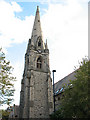
Spire of the former St James's Church, Camberwell
The grade 2 listed church on Knatchbull Road was converted into housing in 1982. See Image
Image: © Stephen Craven
Taken: 22 Sep 2009
0.07 miles
7
Camberwell, Longfield Hall
Former church hall on Knatchbull Road, used by community groups including dance studio and pre-school: http://www.longfieldhall.org.uk/ The building is dated 1889.
Image: © Mike Faherty
Taken: 24 Jun 2014
0.07 miles
8
Black Roof House, Knatchbull Road
This building was formerly the Church of St James the Apostle. It was declared redundant in 1981 and leased in 1982 to the SCD (Society for Co-operative Dwellings) for conversion to residential use as "Black Roof House" - which was still going under that name at 2009.
The building is now surrounded by trees and a fence which make it difficult to get a good view, but the spire Image is still a local landmark. The building is listed grade 2.
Image: © Stephen Craven
Taken: 22 Sep 2009
0.07 miles
9
Cormont Road (1893)
The date as well as the road name is on a stone built into the house on the corner.
Image: © Stephen Craven
Taken: 22 Sep 2009
0.08 miles
10
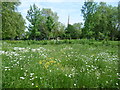
View from within the Nature Conservation Area at Myatts Fields Park
Myatts Fields Park is a delightful example of a small Victorian park. In the early 19th century, market gardens here were run by the Myatt family; some of the finest strawberries in London were grown by Joseph Myatt, and at that time his name was known all over London. The surrounding Minet Estate was built up from the 1870s onwards and the Minet family provided a number of amenities, including the Minet Library and gave the site for Myatts Fields. The Minets were originally French Huguenots and the name Minet means little cat or kitten in French. A little cat was included in many of the buildings when the area was developed by the Minet family. Funds for laying out Myatts Fields were raised by the Metropolitan Public Gardens Association, and the park was opened in 1889, taking its name from the earlier market gardeners. The park has recently been restored to its former glory by a substantial Heritage Lottery Fund grant. A Nature Conservation Area was created and the photograph looks across this to the park. Beyond is the spire of the former St James the Apostle Church, now Black Roof House - see http://www.geograph.org.uk/photo/1502219
Image: © Marathon
Taken: 2 Jun 2012
0.10 miles