IMAGES TAKEN NEAR TO
Denmark Road, LONDON, SE5 9EY
Introduction
This page details the photographs taken nearby to Denmark Road, SE5 9EY by members of the Geograph project.
The Geograph project started in 2005 with the aim of publishing, organising and preserving representative images for every square kilometre of Great Britain, Ireland and the Isle of Man.

There are currently over 7.5m images from over14,400 individuals and you can help contribute to the project by visiting https://www.geograph.org.uk
Image Map (Loading...)


Getting Data...Please wait
Leaflet Map data © OpenStreetMap
Images are licensed for reuse under creativecommons.org/licenses/by-sa/2.0
Notes
- Clicking on the map will re-center to the selected point.
- The higher the marker number, the further away the image location is from the centre of the postcode.
Image Listing (140 Images Found)
Images are licensed for reuse under creativecommons.org/licenses/by-sa/2.0
Image
Details
Distance
1
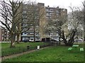
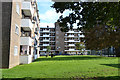
Lansdown House, Crawford Estate, Camberwell, south London
The northwest corner of the estate, in which high-rise slabs and two-storey terraces are arranged around squarish open spaces with trees and play equipment. Pedestrian access is tightly controlled by railings and occasional gates. The tree in flower is likely to be Cherry Plum (Prunus cerasifera). The street glimpsed on the right is Denmark Road.
Old maps show streets of terraced houses through the second half of the 19th century and into the 20th. Around 1950 the area is shown partly cleared. New housing first appears in the late 1950s between Crawford Road and Lowth Road. By 1961 the Crawford Estate is shown complete.
Image: © Robin Stott
Taken: 21 Feb 2017
0.01 miles
2
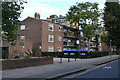
Crawford Estate ? Lichfield House, Denmark Road, Camberwell, London
Image: © Robin Stott
Taken: 17 Sep 2015
0.03 miles
3
Crawford Estate ? Honiton House, Warner Road, Camberwell, London
Image: © Robin Stott
Taken: 17 Sep 2015
0.04 miles
4
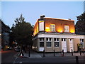
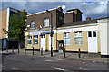
The former Rose and Thistle Public House, Camberwell
This closed and converted pub is on the junction of Warner Road (on the left) and Lowth Road (on the right).
Was still a pub in 2006. With a nice pub sign.
See http://www.flickr.com/photos/markdodds/97556313/.
Now flats.
Image: © David Anstiss
Taken: 2 Oct 2011
0.04 miles
5
Mount Horeb Victorious Church Internationl, Lowth Road, Camberwell
There are many variants of this type of church in the area. This looks as though it was once a pub.
Image: © Robin Stott
Taken: 17 Sep 2015
0.04 miles
6
Mitcham House and Keswick House, Crawford Estate, Camberwell
Mitcham House is on the left. The estate lies between Crawford Road and Denmark Road, with the parallel Lowth Road down the centre.
Image: © Robin Stott
Taken: 17 Sep 2015
0.04 miles
7

Camberwell, Glory Divine Christian Centre
On Warner Road.
Image: © Mike Faherty
Taken: 24 Jun 2014
0.05 miles
8
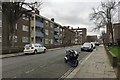
Southeast on Lowth Road, Crawford Estate, Camberwell, south London
Nearest on the left is Barnet House, then the similar Nottingham House with taller Widecombe House beyond. The Crawford Estate was built mainly in the late 1950s.
Image: © Robin Stott
Taken: 21 Feb 2017
0.05 miles
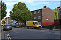
9
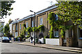
Older terrace houses, Warner Road, Camberwell, London
They have a Regency feel. An OS town plan of 1850 seems to show this terrace. Warner Road was then called Londonderry Road. The ornate cast iron windowbox guards feature a V Image Perhaps the houses date from Victoria's accession.
Image: © Robin Stott
Taken: 17 Sep 2015
0.06 miles
10
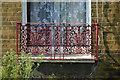
Cast iron windowbox guard, terraced houses, Warner Road, Camberwell, London
There could be an ornate V in the design: might it stand for Victoria? The houses are seen in Image
Image: © Robin Stott
Taken: 17 Sep 2015
0.06 miles