IMAGES TAKEN NEAR TO
Carew Street, LONDON, SE5 9ED
Introduction
This page details the photographs taken nearby to Carew Street, SE5 9ED by members of the Geograph project.
The Geograph project started in 2005 with the aim of publishing, organising and preserving representative images for every square kilometre of Great Britain, Ireland and the Isle of Man.

There are currently over 7.5m images from over14,400 individuals and you can help contribute to the project by visiting https://www.geograph.org.uk
Image Map
Images are licensed for reuse under creativecommons.org/licenses/by-sa/2.0
Notes
- Clicking on the map will re-center to the selected point.
- The higher the marker number, the further away the image location is from the centre of the postcode.
Image Listing (70 Images Found)
Images are licensed for reuse under creativecommons.org/licenses/by-sa/2.0
Image
Details
Distance
1
The Robin Hood & Little John pub
The Robin Hood & Little John pub on the corner of Lilford and Flaxman roads
Image: © Shaun Ferguson
Taken: 18 Sep 2008
0.07 miles
2
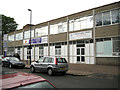
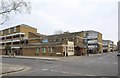
Bizspace and Glorious Family Church, Lilford Road
Small business units are neighbour to one of many such churches for mainly African and Afro-Caribbean congregations. Glorious Family Church is an arm of Glorious International Ministries: "Raising a people for God's glory". On Sundays local streets are vibrant with worshippers in colourful Sunday best and engaged in high-spirited chatter.
Image: © Robin Stott
Taken: 23 Jun 2013
0.08 miles
3
The Paulet Arms (closed)
This pub on Paulet Road, seen from along Templar Street, was closed and "to let" in 2009. It was, according to the legend on the front, established in 1787.
Image: © Stephen Craven
Taken: 22 Sep 2009
0.09 miles
4

Redan Terrace, Brixton, South West London, SE5
Image: © JThomas
Taken: 25 Jul 2022
0.09 miles
5
Crawford Estate ? Lichfield House, Denmark Road, Camberwell, London
Image: © Robin Stott
Taken: 17 Sep 2015
0.10 miles
6
115 Denmark Hill, Camberwell
Beside the railway arches of the Loughborough Junction to Queen's Road, Peckham, Railway line (on the right).
May have been a former pub, but cannot find any reference to any.
Now flats.
Image: © David Anstiss
Taken: 2 Oct 2011
0.10 miles
7
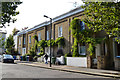
Older terrace houses, Warner Road, Camberwell, London
They have a Regency feel. An OS town plan of 1850 seems to show this terrace. Warner Road was then called Londonderry Road. The ornate cast iron windowbox guards feature a V Image Perhaps the houses date from Victoria's accession.
Image: © Robin Stott
Taken: 17 Sep 2015
0.10 miles
8
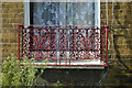
Cast iron windowbox guard, terraced houses, Warner Road, Camberwell, London
There could be an ornate V in the design: might it stand for Victoria? The houses are seen in Image
Image: © Robin Stott
Taken: 17 Sep 2015
0.10 miles
9
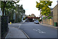
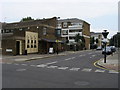
Northwest on Denmark Road, Camberwell, London
The turning to the left is Carew Street. The railway bridge carries the Thameslink route from Blackfriars (right) south towards Loughborough Junction (left).
Image: © Robin Stott
Taken: 17 Sep 2015
0.11 miles
10
The Robin Hood and Little John
Another view of the pub shown in Image, from across Lilford Road. The road crossing it is Flaxman Road. Could there be a connection with the fact that a pair of stones called Robin Hood and Little John are beside the River Nene (near Peterborough), as is a village called Lilford (abeit a lot further upstream)? Probably not.
Image: © Derek Harper
Taken: 11 Mar 2011
0.11 miles