IMAGES TAKEN NEAR TO
Lilford Road, LONDON, SE5 9DZ
Introduction
This page details the photographs taken nearby to Lilford Road, SE5 9DZ by members of the Geograph project.
The Geograph project started in 2005 with the aim of publishing, organising and preserving representative images for every square kilometre of Great Britain, Ireland and the Isle of Man.

There are currently over 7.5m images from over14,400 individuals and you can help contribute to the project by visiting https://www.geograph.org.uk
Image Map
Images are licensed for reuse under creativecommons.org/licenses/by-sa/2.0
Notes
- Clicking on the map will re-center to the selected point.
- The higher the marker number, the further away the image location is from the centre of the postcode.
Image Listing (57 Images Found)
Images are licensed for reuse under creativecommons.org/licenses/by-sa/2.0
Image
Details
Distance
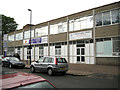
1

Redan Terrace, Brixton, South West London, SE5
Image: © JThomas
Taken: 25 Jul 2022
0.03 miles
2
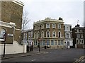
The Robin Hood and Little John
Another view of the pub shown in Image, from across Lilford Road. The road crossing it is Flaxman Road. Could there be a connection with the fact that a pair of stones called Robin Hood and Little John are beside the River Nene (near Peterborough), as is a village called Lilford (abeit a lot further upstream)? Probably not.
Image: © Derek Harper
Taken: 11 Mar 2011
0.04 miles
3
The Robin Hood & Little John pub
The Robin Hood & Little John pub on the corner of Lilford and Flaxman roads
Image: © Shaun Ferguson
Taken: 18 Sep 2008
0.06 miles
4
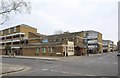
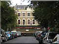
Bizspace and Glorious Family Church, Lilford Road
Small business units are neighbour to one of many such churches for mainly African and Afro-Caribbean congregations. Glorious Family Church is an arm of Glorious International Ministries: "Raising a people for God's glory". On Sundays local streets are vibrant with worshippers in colourful Sunday best and engaged in high-spirited chatter.
Image: © Robin Stott
Taken: 23 Jun 2013
0.06 miles
5

Elam Street Open Space and Healthy Living Site, formerly Foreign Street
By the gate, the yellow-painted sign in the shape of a running man focuses on the dangers of high blood pressure and how to reduce the risk; see Image Another sign inside the gate reads:
Elam Street Open Space
Welcome to Elam Street
Elam Street Open Space provides local people with a ‘green lung’ for play, exercise and relaxation, and to escape the pressures of everyday life. Built on land once occupied by housing, it has been landscaped to include a wetland area crossed by a boardwalk, and a popular playground. Interestingly, part of the wetland embankment is made up of old granite kerbstones which once belonged in Foreign Street, which once stood on this site.
Not far away from Elam Street Open Space is a former period pub, the Wickwood Tavern, built in 1868. This gives us a clue to what was here before the housing. ‘Wickwood’ was the name of a small wood belonging to the Manor of Lambeth Wick, which extended from here to the corner of Loughborough Road and Coldharbour Lane. Wickwood was originally owned by the Archbishops of Canterbury and used for hunting. Later on many of the trees were cut down for building ships and homes, and in time were used for farming and then housing.
Help us look after your parks and open spaces
This site is managed by Lambeth Parks and Greenspaces and patrolled by the Lamabeth Parks Rangers. To help us keep the site clean and safe, or for further information, please report any problems or contact us on 020 7926 9000 or at [email protected]
Image: © Robin Stott
Taken: 23 Jun 2013
0.07 miles
6
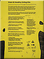
Elam Street Healthy Living Site health advice
This is a close-up of the text of the sign at the Foreign Street gate to the Elam Street Healthy Living Site: see Image It focuses on the risks of high blood pressure and how to reduce them. Note the logos of seven organisations on the sign. No doubt the emphasis on health has secured funding for the creation of this little park.
Image: © Robin Stott
Taken: 23 Jun 2013
0.07 miles
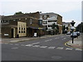
7
Former Wickwood Tavern, Brixton
As http://www.urban75.org/brixton/bars/wickwood-tavern.html reports, the pub, which was built in 1868 (the date appears in the plaque on top of the angle), closed in 2000. This is the crossroads of Flaxman Road (left) with Eastlake Road (right) / Gordon Grove (foreground).
Image: © Derek Harper
Taken: 11 Mar 2011
0.10 miles
8

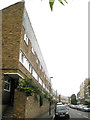
Elam Street
Elam Street is a short street of residential properties of mixed ages.
Image: © Robin Stott
Taken: 23 Jun 2013
0.11 miles
9
The Paulet Arms (closed)
This pub on Paulet Road, seen from along Templar Street, was closed and "to let" in 2009. It was, according to the legend on the front, established in 1787.
Image: © Stephen Craven
Taken: 22 Sep 2009
0.11 miles
10
North on Paulet Road
The west side of Paulet Road is almost entirely developed with three blocks of 20th-century post-war brick-built monopitch-roofed terraced houses with small gardens at the back. Pleasant places to live, I've no doubt, but visually they brutally confront an older mix of terraced housing across the road. I'm sure it looks better, and would certainly photograph better in sunshine.
Image: © Robin Stott
Taken: 23 Jun 2013
0.11 miles