IMAGES TAKEN NEAR TO
Geoffrey Close, Lilford Road, LONDON, SE5 9DA
Introduction
This page details the photographs taken nearby to Geoffrey Close, Lilford Road, SE5 9DA by members of the Geograph project.
The Geograph project started in 2005 with the aim of publishing, organising and preserving representative images for every square kilometre of Great Britain, Ireland and the Isle of Man.

There are currently over 7.5m images from over14,400 individuals and you can help contribute to the project by visiting https://www.geograph.org.uk
Image Map (Loading...)


Getting Data...Please wait
Leaflet Map data © OpenStreetMap
Images are licensed for reuse under creativecommons.org/licenses/by-sa/2.0
Notes
- Clicking on the map will re-center to the selected point.
- The higher the marker number, the further away the image location is from the centre of the postcode.
Image Listing (54 Images Found)
Images are licensed for reuse under creativecommons.org/licenses/by-sa/2.0
Image
Details
Distance
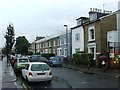
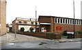
1
The Robin Hood & Little John pub
The Robin Hood & Little John pub on the corner of Lilford and Flaxman roads
Image: © Shaun Ferguson
Taken: 18 Sep 2008
0.02 miles
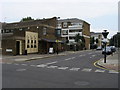
2
The Robin Hood and Little John
Another view of the pub shown in Image, from across Lilford Road. The road crossing it is Flaxman Road. Could there be a connection with the fact that a pair of stones called Robin Hood and Little John are beside the River Nene (near Peterborough), as is a village called Lilford (abeit a lot further upstream)? Probably not.
Image: © Derek Harper
Taken: 11 Mar 2011
0.05 miles
3

Redan Terrace, Brixton, South West London, SE5
Image: © JThomas
Taken: 25 Jul 2022
0.06 miles
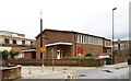
6
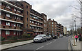
Flats on Lilford Road, Camberwell, south London
Lilford House, nearest, and its neighbour Brigstock House are shown in outline on an OS map of 1938; built on a map of 1949-54. The pale brick block is Winterslow House. The estate is in the London Borough of Lambeth.
Image: © Robin Stott
Taken: 20 Feb 2017
0.08 miles
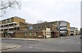
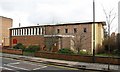
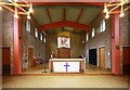
7
St Matthew, Lilford Road, London SE5 - West end
Image: © John Salmon
Taken: 21 Feb 2010
0.08 miles
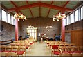
8
St Matthew, Lilford Road, London SE5 - East end
Image: © John Salmon
Taken: 21 Feb 2010
0.08 miles