IMAGES TAKEN NEAR TO
Pirie Close, LONDON, SE5 8TF
Introduction
This page details the photographs taken nearby to Pirie Close, SE5 8TF by members of the Geograph project.
The Geograph project started in 2005 with the aim of publishing, organising and preserving representative images for every square kilometre of Great Britain, Ireland and the Isle of Man.

There are currently over 7.5m images from over14,400 individuals and you can help contribute to the project by visiting https://www.geograph.org.uk
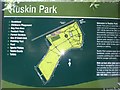
Image Map
Images are licensed for reuse under creativecommons.org/licenses/by-sa/2.0
Notes
- Clicking on the map will re-center to the selected point.
- The higher the marker number, the further away the image location is from the centre of the postcode.
Image Listing (155 Images Found)
Images are licensed for reuse under creativecommons.org/licenses/by-sa/2.0
Image
Details
Distance
2

General William Booth memorial buildings
Quite probably the largest Salvationist building in England, or possibly the world. There's an enormous tower with cross, not photographable unless you have a fish-eye lens.
Image: © Dr Neil Clifton
Taken: 9 Jul 2012
0.03 miles
4

Ruskin Park: The Portico
For explanation, see Image
Image: © Dr Neil Clifton
Taken: 9 Jul 2012
0.05 miles
5
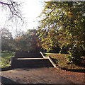
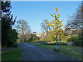
Steps in Ruskin Park
These steps lead up to the Image
The park was busy with early morning joggers.
Image: © David Anstiss
Taken: 2 Oct 2011
0.05 miles

7
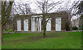
Former portico, Ruskin Park
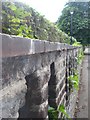
Late-C18th entrance screen of a house which was demolished to make way for the park in 1907. It is currently on English Heritage's Heritage at Risk Register, though restoration plans are apparently in the pipeline. Grade II listed.
Image: © Stephen Richards
Taken: 6 Mar 2011
0.06 miles
9
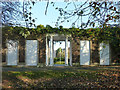
The Portico, Ruskin Park
This used to be part of one of six large villas that fronted Denmark Hill in the 19th century. These were demolished and the land and this portico incorporated into Ruskin Park, which opened in 1907.
Image: © Robin Webster
Taken: 19 Nov 2011
0.06 miles
10
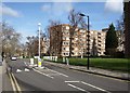
Ruskin Park House
The development, on Champion Hill, is in three blocks; block A, on the right, is the central and was completed first in 1951. Beyond is block C. You can just see the dark corner of block B on the extreme right http://www.ruskinparkhouse.org.uk/estate-information.php .
Image: © Derek Harper
Taken: 11 Mar 2011
0.06 miles