IMAGES TAKEN NEAR TO
Denmark Hill, LONDON, SE5 8ED
Introduction
This page details the photographs taken nearby to Denmark Hill, SE5 8ED by members of the Geograph project.
The Geograph project started in 2005 with the aim of publishing, organising and preserving representative images for every square kilometre of Great Britain, Ireland and the Isle of Man.

There are currently over 7.5m images from over14,400 individuals and you can help contribute to the project by visiting https://www.geograph.org.uk
Image Map
Images are licensed for reuse under creativecommons.org/licenses/by-sa/2.0
Notes
- Clicking on the map will re-center to the selected point.
- The higher the marker number, the further away the image location is from the centre of the postcode.
Image Listing (79 Images Found)
Images are licensed for reuse under creativecommons.org/licenses/by-sa/2.0
Image
Details
Distance
1
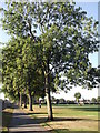
Ruskin Park, London
Ruskin Park, next to Denmark Hill, in southeast London.
Image: © Fan Yang
Taken: 16 Apr 2005
0.06 miles
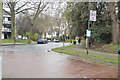
3
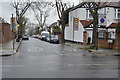
Ferndene Road, Herne Hill
A residential road with houses facing Ruskin Park.
Image: © Richard Dorrell
Taken: 25 Dec 2011
0.08 miles
4
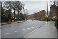
Path in Ruskin Park (2)
One of the perimeter paths in the large park. This path is beside Ferndene Road.
Image: © David Anstiss
Taken: 2 Oct 2011
0.08 miles
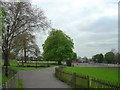
5
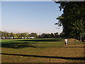
Ruskin Park
Large open-space park in Camberwell. Has a large sports field and a small formal garden and a few listed garden buildings.
Image: © David Anstiss
Taken: 2 Oct 2011
0.10 miles
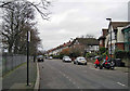
8
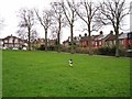
Christmas morning walkies
Cupar the Collie is experiencing a London park for the first time - it's very different to the Skye forests and moors which he is more used to - but he seems to be enjoying himself just as much.
The park is Ruskin Park, Herne Hill. The houses on the right are in Herne Hill Road, while the pair of semis on the far left are in Ferndean Road.
Image: © Richard Dorrell
Taken: 25 Dec 2011
0.11 miles
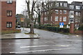
9
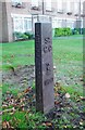
Old Boundary Marker on Denmark Hill
Parish Boundary Marker on grass northwest of Knox House, 169 Denmark Hill SE5 8DU, between the flats and the A215. Formerly on the border of Camberwell and Lambeth St Mary parishes. The border between Southwark and Lambeth is now more towards the centre of Denmark Hill. In raised lettering on the front St / G C / (figure of St Giles) / 1870 and vertically on each side CAMBERWELL PARISH.
Milestone Society National ID: SY_SGC06pb
Image: © L Joseph
Taken: Unknown
0.11 miles