IMAGES TAKEN NEAR TO
Grove Hill Road, LONDON, SE5 8DG
Introduction
This page details the photographs taken nearby to Grove Hill Road, SE5 8DG by members of the Geograph project.
The Geograph project started in 2005 with the aim of publishing, organising and preserving representative images for every square kilometre of Great Britain, Ireland and the Isle of Man.

There are currently over 7.5m images from over14,400 individuals and you can help contribute to the project by visiting https://www.geograph.org.uk
Image Map
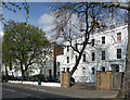
Images are licensed for reuse under creativecommons.org/licenses/by-sa/2.0
Notes
- Clicking on the map will re-center to the selected point.
- The higher the marker number, the further away the image location is from the centre of the postcode.
Image Listing (47 Images Found)
Images are licensed for reuse under creativecommons.org/licenses/by-sa/2.0
Image
Details
Distance
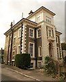
1
197-211 Camberwell Grove
Four linked pairs of houses, built c1830. Stuccoed and mostly with Doric porches. Grade II listed.
Image: © Stephen Richards
Taken: 6 Apr 2012
0.09 miles
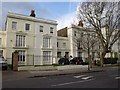
2
House on Grove Park, Camberwell
An impressive detached house on the right of the stretch shown in Image
Image: © Derek Harper
Taken: 11 Mar 2011
0.10 miles
3
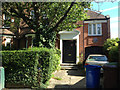
No 9 Grove Park, Camberwell
The plaque above the garage door reads: The Medical Society of London / John Coakley Lettsom M.D. F.R.S. (1744-1815) physician and philanthropist lived at Grove Hill on this site / Founded by [unreadable].
Image: © Robin Stott
Taken: 4 Aug 2013
0.10 miles
4
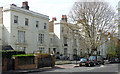
200-218 Camberwell Grove
Five linked pairs of houses, built c1845. Grade II listed.
Image: © Stephen Richards
Taken: 6 Apr 2012
0.11 miles
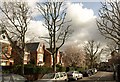
5
Houses on Camberwell Grove
Part of a row of mid-C19 listed houses http://www.britishlistedbuildings.co.uk/en-470733-200-218-camberwell on the west side of the road.
Image: © Derek Harper
Taken: 11 Mar 2011
0.11 miles
6
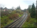
Railway cutting as seen from Copleston Passage
This is the line from Peckham Rye, looking in the direction of East Dulwich
Image: © David Martin
Taken: 18 Mar 2011
0.11 miles
7
Grove Park, Camberwell
The southern, higher arm of Grove Park, with the tree-lined road curving close to the northing gridline.
Image: © Derek Harper
Taken: 11 Mar 2011
0.11 miles
8
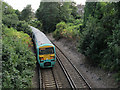
Railway cutting, East Dulwich
The railway runs in a cutting for much of the route between Peckham Rye and East Dulwich. Seen here from the footbridge at Copleston Passage. Compare a similar view only 2.5 years earlier Image showing how quickly the vegetation has regrown.
Image: © Stephen Craven
Taken: 30 Aug 2013
0.12 miles
9
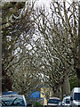
Planes, Grove Park
The street must be in almost total darkness for half the year.
Image: © Stephen Richards
Taken: 6 Apr 2012
0.12 miles
10
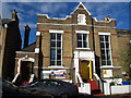
Latter Day Rain Outpouring Revival Church
One of several Pentecostal churches in Peckham, this one is on Copleston Road. The top of the building bears the legend "S S Church House 1902" suggesting it originally belonged to St Saviour's church across the road Image
In the foreground is a hearse attending the funeral that was going on in the church. See Image
Image: © Stephen Craven
Taken: 21 Oct 2014
0.12 miles