IMAGES TAKEN NEAR TO
Kimpton Road, LONDON, SE5 7UW
Introduction
This page details the photographs taken nearby to Kimpton Road, SE5 7UW by members of the Geograph project.
The Geograph project started in 2005 with the aim of publishing, organising and preserving representative images for every square kilometre of Great Britain, Ireland and the Isle of Man.

There are currently over 7.5m images from over14,400 individuals and you can help contribute to the project by visiting https://www.geograph.org.uk
Image Map
Images are licensed for reuse under creativecommons.org/licenses/by-sa/2.0
Notes
- Clicking on the map will re-center to the selected point.
- The higher the marker number, the further away the image location is from the centre of the postcode.
Image Listing (257 Images Found)
Images are licensed for reuse under creativecommons.org/licenses/by-sa/2.0
Image
Details
Distance
1
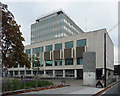
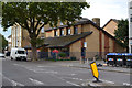
Magistrates' Court, D'Eynsford Road
Built 1965-69. The dark projecting panels are concrete reliefs, the style of which is reminiscent of large murals inside the building. Possibly worth a spot of petty theft to get a proper look (photography not permitted inside).
The area in front is being landscaped in conjunction with the erection of a new library on Camberwell Green.
Image: © Stephen Richards
Taken: 17 Oct 2015
0.02 miles
2
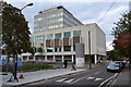
Camberwell Green Magistrates Court and D'Eynsford Road, Camberwell
The new library is out of shot left. New paving, planting and furniture promise to make a pleasant and dignified public space.
Image: © Robin Stott
Taken: 18 Sep 2015
0.02 miles
3
East on Elmington Road, Camberwell
Drayton House, the long terrace, looks as though it may be maisonettes, not flats. This is the rear; the front is seen in Image
Image: © Robin Stott
Taken: 18 Sep 2015
0.02 miles
4
Drayton House, off Lomond Grove, Camberwell
The accommodation appears to be maisonettes that run the full depth of the building, two high. This is the front; the rear faces Elmington Road: Image
Image: © Robin Stott
Taken: 18 Sep 2015
0.03 miles
5
Salvation Army Community Church, Lomond Grove, Camberwell
There appears to be a hostel behind the church, opposite Drayton House on an unnamed cul-de-sac.
Image: © Robin Stott
Taken: 18 Sep 2015
0.04 miles
6
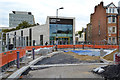
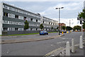
The new Camberwell Library and the reconstruction of Camberwell Green, the road
It's due to open in November, I was told by a librarian leaving the site. The existing library is in Camberwell Church Street: Image In the left background are offices adjoining Camberwell Green Magistrates Court and Youth Court. On the right is D'Eynsford Road and half of Park House. It is not part of the neighbouring Peabody estate but appears to be private flats.
Image: © Robin Stott
Taken: 18 Sep 2015
0.05 miles
8
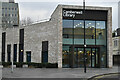
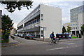
Camberwell Library
Modern library at the northeastern corner of Camberwell Green.
Image: © David Martin
Taken: 29 Jan 2023
0.06 miles
9
North on Lomond Grove, Camberwell
On the left is Lomond House, a Peabody Trust property, which appears to be accommodation attached to Orchard Hill College, which provides for people with special needs or learning difficulties: https://www.orchardhill.ac.uk/about/about-us/
Image: © Robin Stott
Taken: 18 Sep 2015
0.06 miles
10
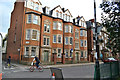
Park House and Brighton House, north end of Camberwell Green
These first appear on an OS map of 1916, replacing small properties. They are not part of the Peabody estate that adjoins them. They appear to be privately owned and let flats.
Image: © Robin Stott
Taken: 18 Sep 2015
0.06 miles