IMAGES TAKEN NEAR TO
St. Giles Road, LONDON, SE5 7RG
Introduction
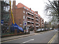
This page details the photographs taken nearby to St. Giles Road, SE5 7RG by members of the Geograph project.
The Geograph project started in 2005 with the aim of publishing, organising and preserving representative images for every square kilometre of Great Britain, Ireland and the Isle of Man.

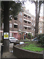
There are currently over 7.5m images from over14,400 individuals and you can help contribute to the project by visiting https://www.geograph.org.uk
Image Map
Images are licensed for reuse under creativecommons.org/licenses/by-sa/2.0
Notes
- Clicking on the map will re-center to the selected point.
- The higher the marker number, the further away the image location is from the centre of the postcode.
Image Listing (168 Images Found)
Images are licensed for reuse under creativecommons.org/licenses/by-sa/2.0
Image
Details
Distance
1
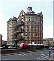
St Giles Tower, Havil Street
An eyecatching relic of St Giles Hospital, the work of W.S. Cross, c1890. This was a ward. For obvious reasons circular wards didn't catch on. Grade II listed.
Now flats.
Image: © Stephen Richards
Taken: 6 Apr 2012
0.05 miles
2
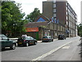
Theatre Peckham
Children's theatre in Havil Street, next to Southwark Town Hall. http://www.theatrepeckham.co.uk/
Image: © Mike Faherty
Taken: 16 Aug 2009
0.06 miles
3
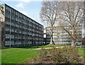
Sceaux Gardens Estate, Havil Street (1)
Pevsner says this was "Camberwell's showpiece [estate] of 1955-59 (Borough Architect F.O. Hayes)". A mixture of big slabs and lower blocks such as these.
Image: © Stephen Richards
Taken: 6 Apr 2012
0.06 miles
4
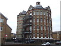
St Giles Tower
Much of the former St Giles Hospital has been demolished and replaced by new housing/ The circular ward block of the old hospital survives, now converted into flats. View from Havil Street.
Image: © Malc McDonald
Taken: 13 Mar 2010
0.06 miles
5
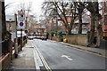
The cleaned east wing of Bentley House, Glebe Estate, Camberwell, south London
The view north on St Giles Road. This monumental estate of local authority flats first appears on an OS map of 1951.
Image: © Robin Stott
Taken: 3 Apr 2016
0.06 miles
6
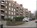
North side of Bentley House, Glebe Estate, Camberwell, south London
The view is along Camberwell Glebe, a service road. This monumental estate of local authority flats first appears on an OS map of 1951.
Image: © Robin Stott
Taken: 3 Apr 2016
0.07 miles
8
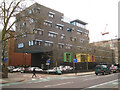
Sunshine House, Peckham Road, Camberwell, south London
A sign at the entrance to this striking building reads: NHS / Guy's and St Thomas' NHS Foundation Trust / Sunshine House / Southwark Children and Young People's Development Centre / Community Health Services.
Image: © Robin Stott
Taken: 3 Apr 2016
0.08 miles
9
Rear of Dryden House, Glebe Estate, Camberwell, south London
This monumental estate of local authority flats first appears on an OS map of 1951. The Holm Oak, left, and other mature trees speak of Victorian grounds, the previous landscape.
Image: © Robin Stott
Taken: 3 Apr 2016
0.08 miles
10
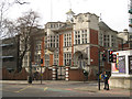
Former Guardians Offices, 29 Peckham Road, Camberwell, south London
There are several similar buildings in the area in this Art Nouveau style. The date over the entrance is 1904. For more information see Christopher Hilton's Image The sign on the gate pillar says Employment Academy.
Image: © Robin Stott
Taken: 3 Apr 2016
0.08 miles