IMAGES TAKEN NEAR TO
Elmington Estate, LONDON, SE5 7HZ
Introduction
This page details the photographs taken nearby to Elmington Estate, SE5 7HZ by members of the Geograph project.
The Geograph project started in 2005 with the aim of publishing, organising and preserving representative images for every square kilometre of Great Britain, Ireland and the Isle of Man.

There are currently over 7.5m images from over14,400 individuals and you can help contribute to the project by visiting https://www.geograph.org.uk
Image Map
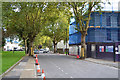
Images are licensed for reuse under creativecommons.org/licenses/by-sa/2.0
Notes
- Clicking on the map will re-center to the selected point.
- The higher the marker number, the further away the image location is from the centre of the postcode.
Image Listing (196 Images Found)
Images are licensed for reuse under creativecommons.org/licenses/by-sa/2.0
Image
Details
Distance
1
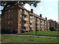
Milton House, Camberwell
Looking southeast to blocks of former council flats, named after poets and believed to have been built in the 1950s. An OS map of the period shows a largely vacant site with Landor House built, and some remaining shops on Camberwell Road. Marvell House is visible, right.
Image: © Robin Stott
Taken: 25 Aug 2013
0.01 miles
2
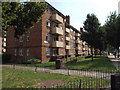
Keats House, Camberwell
Looking southeast to blocks of former council flats, named after poets and believed to have been built in the 1950s. An OS map of the period shows a largely vacant site with Landor House built, and some remaining shops on Camberwell Road.
Image: © Robin Stott
Taken: 25 Aug 2013
0.03 miles
3
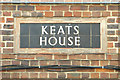
Tiled name panel, Keats House, Camberwell
These blocks of former council flats, named after poets and believed to have been built in the 1950s, all have bespoke tiled name panels at each end.
Image: © Robin Stott
Taken: 25 Aug 2013
0.03 miles
4
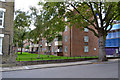
Pope House, off Lomond Grove, Camberwell
Chester Court is on the left Image Blue mesh, right, is around a construction site at the foot of Masterman House flats for 25 houses: 10 private, 15 council.
Image: © Robin Stott
Taken: 18 Sep 2015
0.03 miles
5
West on Bowyer Place, Camberwell, approaching Camberwell Road
A sliver of tall Masterman House appears, left. The light-coloured slab of flats (or maisonettes) is Castlemead on Camberwell Road Image
Image: © Robin Stott
Taken: 18 Sep 2015
0.03 miles
6
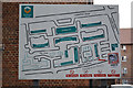
Estate plan near Pope House, Lomond Grove, Camberwell
Most of the blocks are named after English poets: Lamb, Kipling, Keats, Landor, Marvell, Milton, Flecker and Pope. Most are brick-built and date from the post-war period.
Image: © Robin Stott
Taken: 18 Sep 2015
0.04 miles
7
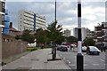
Wyndham Road, Camberwell, seen from the railway
Image: © Christopher Hilton
Taken: 20 May 2014
0.04 miles
8
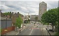
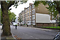
Kenyon House on Bowyer Place, Camberwell
A nice shot of an adult cycling on the pavement by chance. It happens a lot in London and they are often preferred to the cycle lanes.
Image: © David Howard
Taken: 27 Mar 2022
0.04 miles
9
South on Lomond Grove, Camberwell
On the left are the Guardian company's premises Image At centre is the painted side of Chester Court Image On the right is the construction site below Masterman House Image
Image: © Robin Stott
Taken: 18 Sep 2015
0.04 miles
10
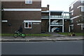
Chester Court and Chester Buildings, Lomond Grove, Camberwell
Chester Buildings at the rear are accessed through a pend (way through a building), seen to the right of the cyclist. There's nothing to say whether these are private flats or philanthropic housing.
Image: © Robin Stott
Taken: 18 Sep 2015
0.04 miles