IMAGES TAKEN NEAR TO
Marianne Close, LONDON, SE5 7FH
Introduction
This page details the photographs taken nearby to Marianne Close, SE5 7FH by members of the Geograph project.
The Geograph project started in 2005 with the aim of publishing, organising and preserving representative images for every square kilometre of Great Britain, Ireland and the Isle of Man.

There are currently over 7.5m images from over14,400 individuals and you can help contribute to the project by visiting https://www.geograph.org.uk
Image Map
Images are licensed for reuse under creativecommons.org/licenses/by-sa/2.0
Notes
- Clicking on the map will re-center to the selected point.
- The higher the marker number, the further away the image location is from the centre of the postcode.
Image Listing (160 Images Found)
Images are licensed for reuse under creativecommons.org/licenses/by-sa/2.0
Image
Details
Distance
1
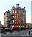
St Giles Tower, Havil Street
An eyecatching relic of St Giles Hospital, the work of W.S. Cross, c1890. This was a ward. For obvious reasons circular wards didn't catch on. Grade II listed.
Now flats.
Image: © Stephen Richards
Taken: 6 Apr 2012
0.05 miles
2
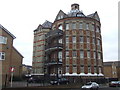
St Giles Tower
Much of the former St Giles Hospital has been demolished and replaced by new housing/ The circular ward block of the old hospital survives, now converted into flats. View from Havil Street.
Image: © Malc McDonald
Taken: 13 Mar 2010
0.06 miles
3
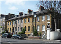
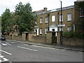
1-4 Brunswick Villas
A pleasant run of four houses with arched ground floor windows. Probably late Georgian so perhaps c1830, or a little later as they are not listed.
Image: © Stephen Richards
Taken: 6 Apr 2012
0.06 miles
4
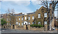
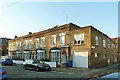
159-163 Havil Street
Built as the Bethel Asylum for aged women, 1837, by William Peacock who founded the Aged Pilgrims' Home nearby (Image]). Grade II listed.
Now flats for women and men of all ages and mental states.
Image: © Stephen Richards
Taken: 6 Apr 2012
0.08 miles
5
Camberwell, former asylum
In Havil Street; former asylum for aged women, built 1837. Listed by English Heritage http://www.imagesofengland.org.uk/Details/Default.aspx?id=471002&mode=adv
Image: © Mike Faherty
Taken: 16 Aug 2009
0.08 miles
6
1 - 9 (odds) Ada Road, SE5
Late Victorian houses with a more recent extension this end.
Image: © Robin Webster
Taken: 19 Nov 2011
0.08 miles
7
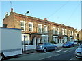
1 - 9 (odds) Ada Road, SE5
Late Victorian houses with a more recent extension at the far end.
Image: © Robin Webster
Taken: 19 Nov 2011
0.08 miles
8

Welcome to Brunswick Park
A small park with two tennis courts, a basketball/kickabout area and a small children's play apparatus area, the last just beyond the hedge.
Image: © Robin Webster
Taken: 19 Nov 2011
0.09 miles
9
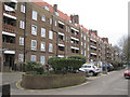
North side of Bentley House, Glebe Estate, Camberwell, south London
The view is along Camberwell Glebe, a service road. This monumental estate of local authority flats first appears on an OS map of 1951.
Image: © Robin Stott
Taken: 3 Apr 2016
0.09 miles
10
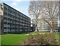
Sceaux Gardens Estate, Havil Street (1)
Pevsner says this was "Camberwell's showpiece [estate] of 1955-59 (Borough Architect F.O. Hayes)". A mixture of big slabs and lower blocks such as these.
Image: © Stephen Richards
Taken: 6 Apr 2012
0.09 miles