IMAGES TAKEN NEAR TO
Marchwood Close, LONDON, SE5 7EX
Introduction
This page details the photographs taken nearby to Marchwood Close, SE5 7EX by members of the Geograph project.
The Geograph project started in 2005 with the aim of publishing, organising and preserving representative images for every square kilometre of Great Britain, Ireland and the Isle of Man.

There are currently over 7.5m images from over14,400 individuals and you can help contribute to the project by visiting https://www.geograph.org.uk
Image Map
Images are licensed for reuse under creativecommons.org/licenses/by-sa/2.0
Notes
- Clicking on the map will re-center to the selected point.
- The higher the marker number, the further away the image location is from the centre of the postcode.
Image Listing (153 Images Found)
Images are licensed for reuse under creativecommons.org/licenses/by-sa/2.0
Image
Details
Distance
1
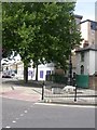
Peckham, pump and trough
At the junction of Peckham Grove & Southampton Way; pump surmounted by standard lamp, listed by English Heritage http://www.imagesofengland.org.uk/Details/Default.aspx?id=471332&mode=adv To the left, the remains of a horse trough.
Image: © Mike Faherty
Taken: 16 Aug 2009
0.02 miles
2
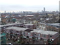
Southampton Way Estate, SE5
A view from the 9th floor of a tower block on Southampton Way Estate, in Camberwell, South East London. The buildings in the foreground probably date from the 1960s or 1970s. Behind them are Victoria terraced houses. Further in the distance are several more blocks of flats built in the 1960s/70s.
Several London landmarks are visible on the skyline, including Westminster Cathedral, the London Eye and the BT Tower.
Image: © Malc McDonald
Taken: 6 Mar 2012
0.02 miles
3
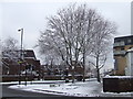
Southampton Way, SE5 in the snow
A picture of Southampton Way, on the border of Peckham and Camberwell in South East London, taken on a cold winter's morning.
Image: © Malc McDonald
Taken: 21 Jan 2013
0.03 miles
4
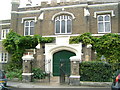
Pilgrims Cloister Sedgemoor Place. Former Asylum
Image: © Sarah McGuire
Taken: 24 Oct 2007
0.04 miles
5
Southampton Way/Peckham Grove junction
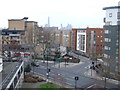
This view was taken from the 5th floor of a block of flats on Southampton Way Estate, on the border of Camberwell and Peckham. In the foreground is recently-built housing, while tower blocks in the City of London are visible in the distance.
Compare this image with one taken from the 9th floor here: Image
Image: © Malc McDonald
Taken: 6 Mar 2012
0.04 miles
6
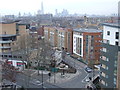
Peckham Grove, SE15
A view from the 9th floor of a block of flats just off Southampton Way, SE5. This view looks northwards towards the City of London. In the foreground are recently-built flats. Older blocks of flats which date from the 1960s and 1970s are visible further away. In the distance are tower blocks in the City of london along with the Shard, nearing completion. Also just visible, on the skyline to the left of the image, is the dome of St. Paul's Cathedral.
Compare this view with one taken from the 5th floor: Image
Image: © Malc McDonald
Taken: 6 Mar 2012
0.04 miles
7
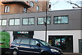
Puregym on Southampton Way, North Peckham
Image: © David Howard
Taken: 27 Mar 2022
0.06 miles
8
116 Sedgmoor Place
Castellated, built as the Aged Pilgrims' Home, c1837, almshouses for poor Protestants. There is a quadrangle behind. Grade II listed.
Image: © Stephen Richards
Taken: 6 Apr 2012
0.06 miles
9
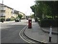
Camberwell, postbox
Victorian postbox on Southampton Way, ID SE5 52.
Image: © Mike Faherty
Taken: 16 Aug 2009
0.06 miles
10
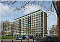
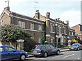
Southampton Way Estate, Southampton Way
Perhaps dating from the late 1950s, and unusually not looking as if it has been revamped much since then.
Image: © Stephen Richards
Taken: 6 Apr 2012
0.06 miles