IMAGES TAKEN NEAR TO
John Ruskin Street, LONDON, SE5 0XQ
Introduction
This page details the photographs taken nearby to John Ruskin Street, SE5 0XQ by members of the Geograph project.
The Geograph project started in 2005 with the aim of publishing, organising and preserving representative images for every square kilometre of Great Britain, Ireland and the Isle of Man.

There are currently over 7.5m images from over14,400 individuals and you can help contribute to the project by visiting https://www.geograph.org.uk
Image Map
Images are licensed for reuse under creativecommons.org/licenses/by-sa/2.0
Notes
- Clicking on the map will re-center to the selected point.
- The higher the marker number, the further away the image location is from the centre of the postcode.
Image Listing (129 Images Found)
Images are licensed for reuse under creativecommons.org/licenses/by-sa/2.0
Image
Details
Distance
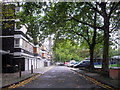
2
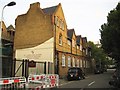
Camberwell: St John the Divine Primary School, SE5
This is the Warham Street frontage of this Victorian Church of England Junior Mixed and Infant School.
Warham Street ends today at the white wall in the distance, but, prior to the Second World War and the wholesale redevelopment of this area that followed, it used to run right through, across where Kennington Park is now, to St Agnes Place.
Image: © Nigel Cox
Taken: 11 Sep 2009
0.05 miles
3
Aberfeldy House, John Ruskin Street
These flats are at the junction of Camberwell New Road.
Image: © Danny P Robinson
Taken: 1 Jun 2006
0.06 miles
4
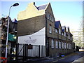
St John the Divine Church of England Primary School
Warham Street, Camberwell
Image: © PAUL FARMER
Taken: 15 Nov 2009
0.06 miles
6
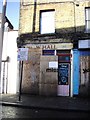
New Camberwell Squatted Centre
At 192 Warham Street
Image: © PAUL FARMER
Taken: 15 Nov 2009
0.07 miles
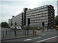
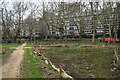
7
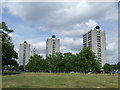
Brandon Estate, Kennington Park
The Brandon Estate comprises several tower blocks as well as low-rise housing.
The grassland in the foreground is called Kennington Open Space. This adjoins part of Kennington Park - but the park is in the London Borough of Lambeth, while the Open Space is in the London Borough of Southwark (as is Brandon Estate).
Image: © Malc McDonald
Taken: 30 May 2011
0.07 miles
8
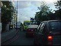
A202 - Camberwell New Road, SE5
A notorious bottleneck along Camberwell New Road by John Ruskin Street, heading towards Camberwell Green.
Image: © Phillip Perry
Taken: 31 Oct 2008
0.07 miles
10
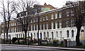
122-138 Camberwell New Road
One of the more uniform, and best quality, Georgian terraces on a street rich in Georgian houses. A couple of houses have been lost at the far end, but the remainder are three storeys over a basement and of three bays. All tied together by the stuccoed ground floor, pierced by arched windows, and stuccoed cornice. Early C19th. The lesser value of land in suburban areas sometimes allowed builders to include front gardens. Grade II listed.
Image: © Stephen Richards
Taken: 15 Apr 2012
0.10 miles